
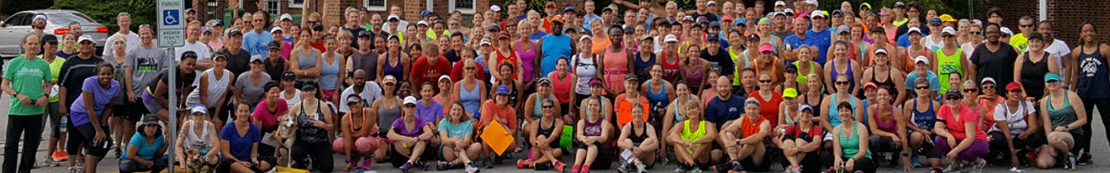

Run #8
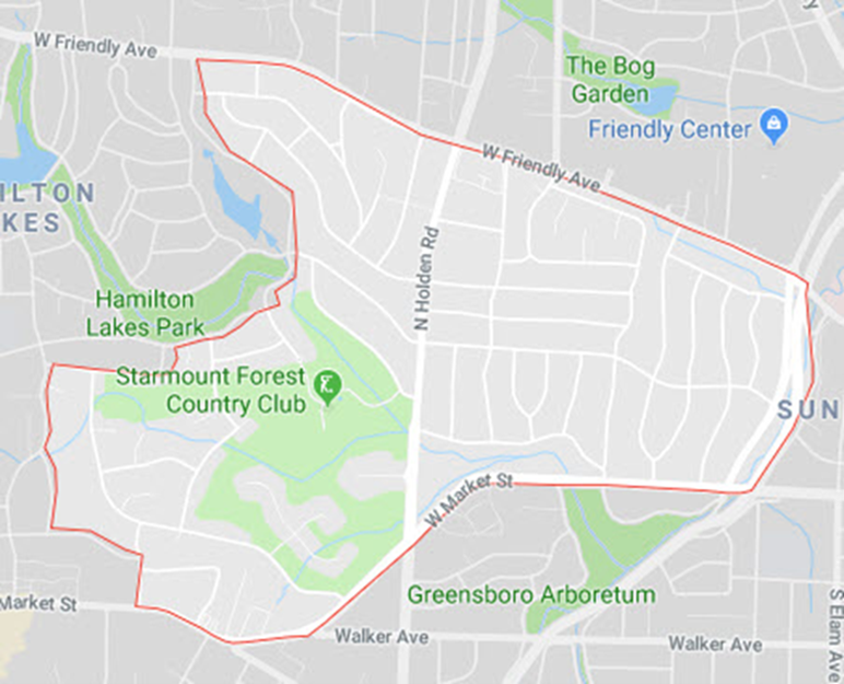
The Bog Garden, Starmount Forest, Greensboro Arboretum, Lindley Park
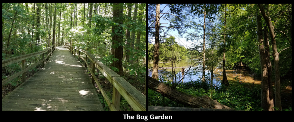
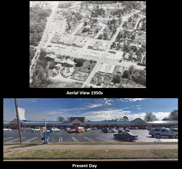
The Bog Garden
In 1987, Dr. Joe Christian, a primary care physician for many years in Greensboro, was visiting the Bicentennial Garden when he noticed a large bass in the creek swimming downstream. He followed it across the street and found what he described as “a beautiful wilderness of swamp, creek, established trees, and what once had been a beautiful lake…”it is now in foul shape, dam broken, trash and weeds in the lake, beer cans, acres of briars, dead limbs…”
The property, a bird sanctuary, had been part of Starmount Farms since the early 1930s. It was near the home of Blanche Sternberger Benjamin, widow of Edward Benjamin, founder of Starmount Company and developer of the Starmount Forest neighborhood and the nearby Friendly Shopping Center. In 1987, Starmount Company was ready to develop the Starmount Farms subdivision. But the lake on the parcel had silted in and transformed the area upstream into a 15-acre wetland area. The lake and wetlands are fed by a creek that is a tributary of North Buffalo Creek. Through Starmount Company, Blanche Benjamin offered the land, lake and dam to the City of Greensboro after offering to rebuild the dam, renovate the lake to its original depth of 15-18 feet, and build a concrete sidewalk and observation deck on the property.
Over the next few years, Christian worked with City staff, numerous volunteers and local nurseries to develop plans, clear paths and weeds, and acquire, rescue and install thousands of plants which would thrive on this property. Private funds were donated to construct bridges, stone steps to traverse the hillside, and an elevated winding walkway was constructed to provide access throughout the entire wetland and to border the lake.
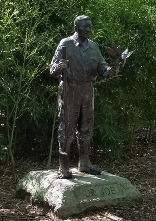
In 2005, construction began on a 150-foot recirculating, man-made waterfall – the first waterfall in Greensboro. The Dr. Joe Christian Serenity Falls were dedicated in 2007.
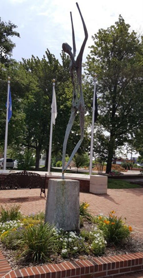
And in 2008, under the leadership of Dr. John Chandler, friends and patrons of the Bog Garden contributed funds to commission a bronze statue, in the likeness of “Dr. Joe”, to honor his tireless efforts to develop the Bog Garden into the unique attraction it has become. The statue, created by Maria Kirby-Smith, is placed at the garden’s entrance. For more information go to www.greensborobeautiful.org
Starmount Forest
Starmount Forest was platted in the mid-1920s as part of the Hamilton Lakes subdivision. The neighborhood was cut from the eastern part of Hamilton Lakes by local developers Edward and Blanche Sternberger Benjamin in 1927. Building began in earnest after the close of World War II and includes the Starmount Country Club, a focal point of both Starmount Forest and Hamilton Lakes subdivisions.
Starmount Forest developed quickly in the years following World War II, resulting in homogeneity of style, form and detail. The housing of Starmount Forest is mostly brick, well detailed, yet modest in size. The majority of dwellings are one or one and one-half story “Cape Cod” form houses. Two-story dwellings are concentrated on Madison Avenue, which transverses the neighborhood from east to west. The predominant style is Minimal Traditional, defined as side-gable or gable-and-wing dwellings with Colonial Revival details such as door surrounds with broken pediments and pilasters, six-over-six or eight-over-eight windows with shutters, dormers, and Chippendale balustrades. As one travels north toward West Friendly Avenue, ranches and split-level houses are interspersed with the predominant Minimal Traditional dwellings. The details of these 1950s and 60s-era houses display a preference for the Colonial Revival. (Infor obtained from Greesnboro’s Historic Homes)
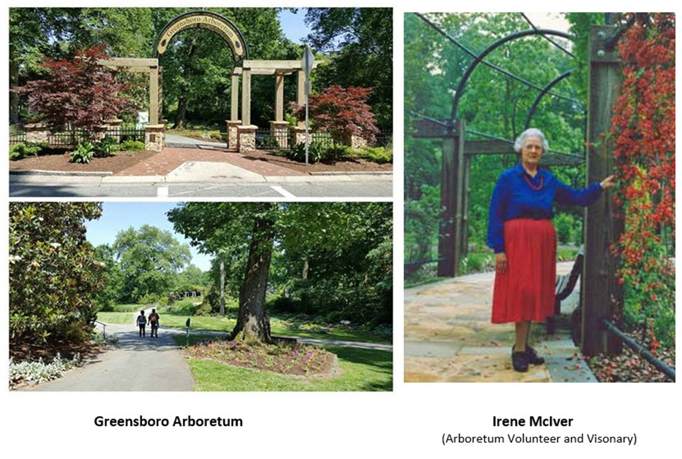
Greensboro Arboretum
You’ve probably seen it as you fly by on Wendover Ave, but have you had a chance to walk through the Greensboro Arboretum? RunTheBoro Run #8 5.9 and 10-mile runners will run through this beautiful Greensboro treasure.
This 17-acre site features 14 plant collections, special display gardens and distinct structural features. The extensive variety of plants offers rich educational opportunities for children and adults, landscape designers, and homeowners.
The garden is open year-round. Hours vary throughout the year. Admission is free.
The Greensboro Arboretum began as a joint project of Greensboro Beautiful and the Greensboro Parks & Recreation Department to provide the community with an outstanding collection of plants for study and enjoyment. In the late 70’s, after completing Bicentennial Garden, Greensboro Beautiful was searching for another area to serve the community and attract visitors to Greensboro. The City of Greensboro offered 17 acres within Lindley Park – centrally located and easily accessible from all parts of the city by major thoroughfares. It was also the site of remnants of the Anniversary Garden, a project of the Greensboro Council of Garden Clubs in the 50’s. Greensboro Beautiful volunteer and Arboretum visionary, Irene McIver, proposed that special care be given to construct a landscape display garden which would utilize the natural topography of the site, which ranges from steep, almost cliff-like slopes to flat, meadow-like plains. She also suggested that the garden be constructed around existing wooded and open areas, and include collections of woody plants labeled for education, recreation and enjoyment of the public.
Greensboro Beautiful consulted with horticulture professors and NC State University, and contracted with Virginia Tech landscape architect and horticulture professor, Robert McDuffie, for a design and master plan. The plan involved woody ground covers, trees and shrubs to be grouped into labeled collection areas according to habit, family, color, growing conditions, and seasonal interest. Plant species selected were particularly hardy to the Piedmont Region of North Carolina. The plant material in each collection was separated by turf areas and paved walkways to allow close inspection of plants.
With the design in place and construction ready to begin, McIver began soliciting support from the community. Local businesses and nurseries were especially generous with contributions of plants and construction materials. Memorial and honor gifts were received and helped purchase trees and benches for the arboretum. City staff assumed responsibility for site preparation, installation of drainage, irrigation, planting, and maintenance. Construction began in 1986 and was completed in 1991.
In appreciation for her tireless dedication to the realization of the Greensboro Arboretum, Greensboro Beautiful named the Vine Collection in honor of Irene McIver.
The garden was formally opened to the public in 1991, and has proven to be a regional treasure – a living gallery of beauty, a learning laboratory for all ages, and a unique place for a tranquil walk. (Information gathered from Greensboro Beautiful.)
Greensboro Beautiful consulted with horticulture professors and NC State University, and contracted with Virginia Tech landscape architect and horticulture professor, Robert McDuffie, for a design and master plan. The plan involved woody ground covers, trees and shrubs to be grouped into labeled collection areas according to habit, family, color, growing conditions, and seasonal interest. Plant species selected were particularly hardy to the Piedmont Region of North Carolina. The plant material in each collection was separated by turf areas and paved walkways to allow close inspection of plants.
With the design in place and construction ready to begin, McIver began soliciting support from the community. Local businesses and nurseries were especially generous with contributions of plants and construction materials. Memorial and honor gifts were received and helped purchase trees and benches for the arboretum. City staff assumed responsibility for site preparation, installation of drainage, irrigation, planting, and maintenance. Construction began in 1986 and was completed in 1991.
In appreciation for her tireless dedication to the realization of the Greensboro Arboretum, Greensboro Beautiful named the Vine Collection in honor of Irene McIver.
The garden was formally opened to the public in 1991, and has proven to be a regional treasure – a living gallery of beauty, a learning laboratory for all ages, and a unique place for a tranquil walk. (For more information, go to www.greensborobeautiful.com)
Lindley Park (see Run #7)

Run #7
Fisher Park, Lake Daniel Greenway, Lake Daniel*, Friendly Homes**, Sunset Hills**, Lindley Park**, Green Valley**, Old Irving Park (* Short only, **Long only)
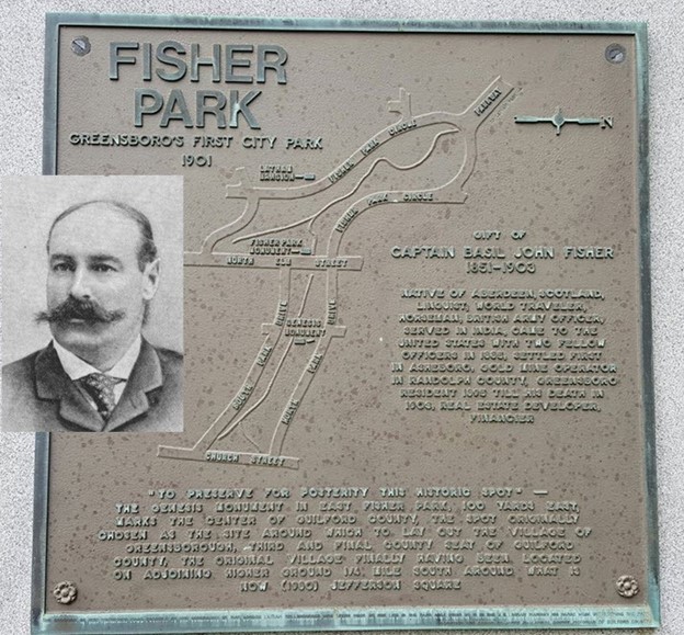
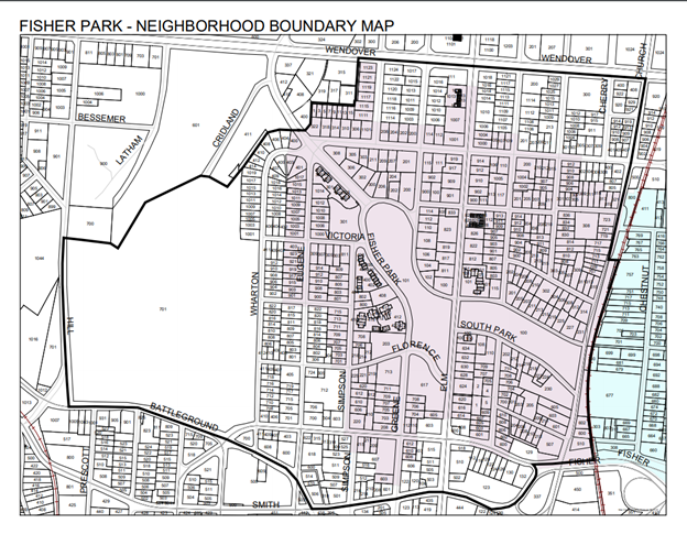
Fisher Park
Did You Know? Fisher Park is named for Captain Basil John Fisher, a Scotsman and Captain in the British Army, who immigrated to the U.S. and settled in Asheboro, NC, Randolph County with hopes of making a fortune in gold-mining. That being unsuccessful, Fisher began purchasing real estate, including some wooded land immediately north of the small town of Greensboro. The area, then known as “Lindsay’s Woods” was used as a littered dumping ground by city residents … quite humble beginnings.
The neighborhood traces it’s beginnings to 1902 when Captain Fisher donated 28 acres of his land holdings for development of a “suburb” of Greensboro. In exchange, the city paid $5 and agreed to build a “driveway” within the donated land. This “driveway” became our signature public streets, Fisher Park Circle, North Park Drive, and South Park Drive. Land lying within that space became a public park, Fisher Park. (Information obtained from www.firsherparknc.org)
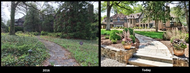
Runners on both the shorter and longer routes will run along Fisher Park Circle. They’ll soon pass a stately mansion known as Hillside. Once a beautiful sprawling home, the house fell into disrepair. I discovered from Preservation Greensboro, that the original owner of the home, built in the late 1920s, was Julian Price. Originally from Virginia, Price found early employment with the railroad, which led to service as a telegraph operator and dispatcher for the Southern Railway. This position took him to Durham in 1895 and shortly thereafter to Greensboro. In Greensboro, Price accepted a position with the American Tobacco Company and in 1905 went to Greensboro Life Insurance Company. Greensboro Life joined with Jefferson Standard in 1912, and Price was elected vice-president and agency manager. He was promoted to president of the company in 1919 and served in that capacity for twenty-seven years until 1946. Price and his wife lived in the house until their deaths and then their son and his wife continued to live in the house until they donated it to the First Presbyterian Church in 1959. The church used the house as its Manse. Then in 1975, Sandra and Glynn Cowart bought the home from the church for $125,000. Sandra ran her highly successful design business from the house. The property was listed as a Guilford County Landmark in 1983, but the following decade, the home fell into decay. The estate was vulnerable to being destroyed for redevelopment, but Preservation Greensboro worked with the North Carolina State Historic Preservation Office and Sandra to see the house gain statewide significance in order to prevent demolition. As the condition of the house deteriorated and finances grew increasing restricted, the mortgage holder auctioned the property in 2016. The purchasers were Eric and Michael Fuko-Rizzo, who completed a extensive restoration of the property. (You may have seen Eric and Michael and the Hillside home featured on an episode of the A&E show Hoarders). Hoarders helped clean out the house. Eric and Michael, sold much of the contents and gave the proceeds of the sale to Sandra.) They worked with Fisher Park landscape architect Chip Callaway to rejuvenate the grounds, which were taken over by invasive plants such as bamboo, ivy, poison ivy, and honeysuckle. They also coordinated their work with Preservation Greensboro and a Designer Show House Tour open to the public was held in April and May, 2018.
Lake Daniel
When I moved to Greensboro in 1998, I heard about Lake Daniel and the Lake Daniel Greenway, but I could never find a lake. Does one exist?
Yep, there is a small man made lake or reservoir that is a part of the water system for Greensboro. It’s actually the only visible body of water in the heart of the city. It’s surrounded by a beautiful wooded area. This area is in the city park system because the people in Lake Daniel neighborhood campaigned to make it so. New regulations now require that part of the reservoir be covered so the water can be used to supplement the city water needs. The back portion of the reservoir is covered with a flat cover and the front portion is to continue to be visible from Benjamin Parkway, a heavily traveled artery into downtown. The drive/walkway around the reservoir still provides a pleasant place for the people who enjoy visiting the park.

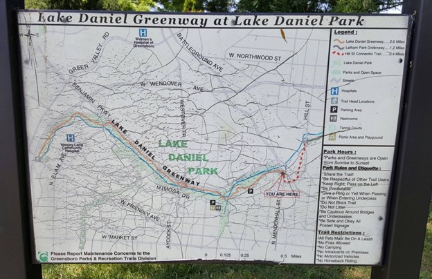
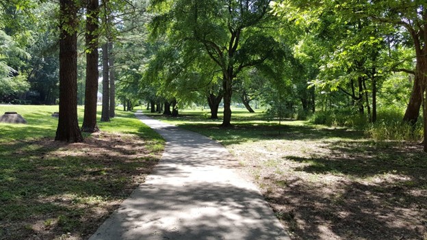
Lake Daniel Greenway
Located in Lake Daniel Park, the Lake Daniel Greenway is a paved multi-use path that stretches two miles from West Friendly Avenue to Mendenhall Street, west to east, paralleling Benjamin Parkway most of the way. Exercise stations are situated along the path for a great workout. In addition, the park offers public tennis courts, a basketball court, and a children’s playground.
The western trailhead is located on West Friendly Avenue, just east of the Wendover Avenue overpass and adjacent to Wesley Long Community Hospital. The eastern trailhead is located at the intersection of East Lake Drive and Mendenhall Street. Parking for the greenway is available at Mimosa Drive and on East Lake Drive.
Lake Daniel Greenway provides a paved multi-use route that, when incorporated with the Latham Park Greenway, connects Friendly Shopping Center to the downtown area. Lake Daniel Park and Latham Park are linked by the Hill Street Connector Trail that incorporates sidewalk and a paved path parallel to Hill Street.
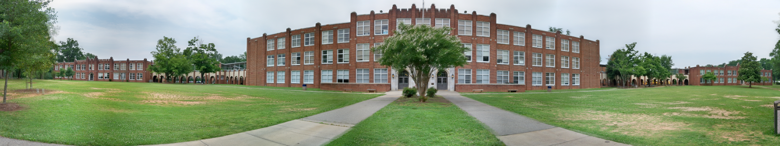
Grimsley High School
Even though the Greensboro City Schools had been in existence since 1875, a separate “high school department” beyond the grammar school level was not created until 1899, when Superintendent George A. Grimsley arranged for the purchase of the old St. Agnes Catholic Church building on North Forbis Street in order to establish Greensboro High School. (The two-story church structure had been constructed in 1877 and has been described as a high-pitched frame building.) Opening in the fall of 1899 and operating at that site until 1910, GHS became one of the first public high schools in North Carolina. The school was located behind the First Presbyterian Church (now the Greensboro Historical Museum) and next door to the Lindsay Street Grammar School, on part of the land occupied today by the new Greensboro Public Library.
On January 16, 1962, Greensboro Senior High School changed its name to Grimsley Senior High School after principal A.P. Routh received a surprise phone call from a Greensboro City Schools official informing the school that the school board was going to change the name of the high school that night, and they had three hours to choose a new name or the school board would choose for them. Routh and the staff chose Grimsley because there was a strong desire to keep the school GHS, and George A. Grimsley was the superintendent of Greensboro City Schools when Greensboro Senior was first established in 1899. The name change took effect on July 1, 1962.
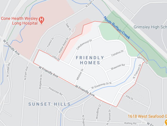
Friendly Homes
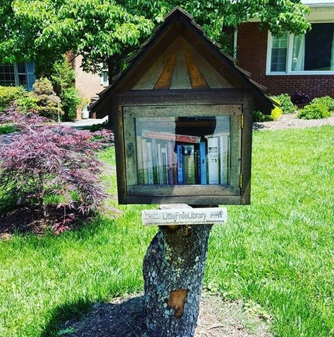
Friendly Homes is a little known neighborhood nestled between Wesley Long Hospital on the west, bordered west, north and east by Buffalo Creek. The Lake Daniel Greenway borders two sides of the neighborhood. Not much is known about the development of this small hilly neighborhood, but it’s a great neighborhood to run through. The lending library pictured below is found on Candlewood Dr. in the neighborhood.
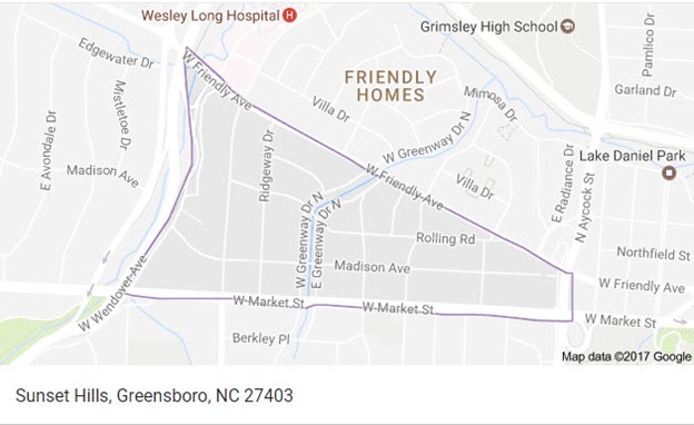
Sunset Hills
The Sunset Hills neighborhood was developed by the A.K. Moore Company, after its success buidling the Westerwood neighborhood (which you’ll run/walk through in an upcoming RunTheBoro run/walk). Sunset Hills began as a community originally not in the city limits. It originally had a few residents (such as the house described in the next paragraph built in 1895), but in 1923 the city limits were extended to North Buffalo Creek, taking in the Sunset Hills community. The promotional information for Sunset Hills boasted rolling hills and a community park. The park still exists between W. Greenway Drive and E. Greenway Drive.
Houses in the Sunset Hills Historic District represent a wide range of forms and styles typical of the late 1920s through the early 1960s. Reflecting the emerging role of the automobile during the period when Sunset Hills began its development, many properties include historic garages with most constructed of lapped wood siding, German siding, or, in a few cases, brick. The oldest dwelling in Sunset Hills is the two-story, three-bay, frame dwelling at 2702 West Market Street. According to neighborhood residents, the house was built in 1895 on the south side of West Market Street, but was moved to its present site around 1932. The presence of the late-nineteenth-century dwelling on West Market Street is a bit out of place for Sunset Hills. The neighborhood was developed primarily from the mid-1920s through the post-World War II era. The district contains architectural styles and forms typical of suburban developments of this period. This early home was at one time considered in a very rural area away from downtown.
Sunset Hills is also the neighborhood in which the Running of the Balls takes place each December with all the hanging lighted balls in trees along the course.
Lindley Park
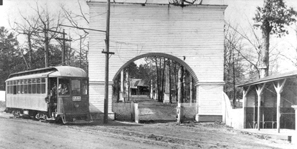
Did you know…the area was named after local businessman John Van Lindley, a Quaker whose business interests ranged from nurseries, sewer pipes, insurance to peach growing in the late 19th and early 20th centuries. In 1902, he donated 60 acres of land along Spring Garden Street for a recreation complex boasting a man-made lake, pavilion, amusement park, casino, and bowling alleys. Today, this area still exists as the park between Spring Garden Street and Walker Ave. Scroll down to see a period picture of the park entrance with one of the many Greensboro trolley cars that brought people in from “the city” to enjoy the park.Below is a map of current day Lindley Park and below are a couple early pictures of Lindley park in the era of the greensboro trolley system.
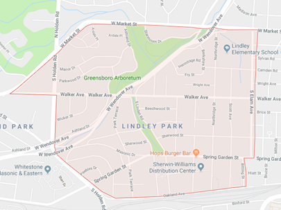
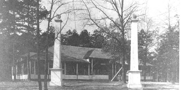
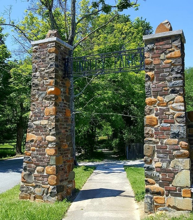
When the lake and amusement park closed in 1917, the City hired Earle Sumner Draper to design a planned neighborhood development and what followed was the Lindley Park neighborhood. Many original design elements still remain, such as the stone column entryways and tree-lined streets.
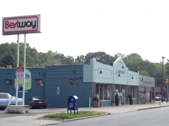
Longest Continuously Operated Grocery Store
Did you know the longest continuously operated grocery store in Greensboro is located in Lindley Park? Yep! If RunTheBoro Run #7 participants look to their left just before reaching Elam Ave, they’ll see the Bestway store. It’s the longest continuously operated grocery store in Greensboro. The location was originally an A&P which closed in 1957, re-opening the next year as Smith’s Bi-Rite. The Bi-Rite co-op was originally established to help independent grocers compete with big chains. All the stores that formed the co-op in 1956 were independents, and R.M. Butler ended up as president of the co-op.
Butler eventually owned the Walker Avenue Bi-Rite with eight others in the co-op. In 1972, Butler rebranded these stores as Bestway. They were a pretty big player in Greensboro in the 1970s and early 1980s, but they apparently expanded too quickly. The beginning of the end was their purchase of a former Kroger on Battleground Avenue (it’s now EarthFare) in 1984. By 1986, the chain was bankrupt, and Butler ended up selling or liquidating all the stores except the one on Walker Avenue, which oddly enough, had the lowest sales volume but was the most profitable one of the bunch. (for more info on Bestway go to Yesweekly.com) Really in to the history of grocery stores? Go to groceteria.com
Green Valley
The long route runners will run up Green Valley Rd during RunTheBoro Run #7. If you’ve ever traveled down Green Valley Rd on your way to Friendly Center you may notice all the large office buildings after passing Women’s Hospital. Until recently some of that land was still undeveloped, just open grassy land. Did you know this area use to be a golf course? According to Yes Weekly, this was the location of the Green Valley Country Club, Greensboro’s first public golf course.
The course was originally known as Green Valley Golf Course before it started accepting memberships as a semi-private club in the mid-’60s and became Green Valley Country Club. It was also known as Green Valley Golf Club for a period. It’s a bit confusing, but for those familiar with the course, the changes had little effect.
In a Yes Weekly article, Aubrey Apple Jr. (whose father served as the course’s head golf professional for nearly 40 years) said, “Everyone referred to it as ‘The Valley,” Unlike other clubs in the area, The Valley did not cater to affluence. “It was more of a middle-income country club,” Apple said. “It didn’t matter how much money you had or how much you didn’t have. You came to the Valley and you were just another member.”
It’s tough to visualize now, but when the course opened in 1928, its surrounding area was mostly farmland. Its original clubhouse was made from a sheep barn and hog sheds neighbored its borders. With so much of the area still undeveloped, Grimsley High School was the nearest establishment to the course.
Originally a 9-hole course, Green Valley was preceded only by Greensboro Country Club and Sedgefield County Club, making it Greensboro’s third golf course and its first public one. However, its initial run was not a long one, as it closed in 1934. Starmount Company had opened the Starmount Forest Country Club four years prior and it closed Green Valley “in order to get more members to join the country club,” Aycock wrote in a 1984 News & Record article that chronicled the course’s history. The Valley remained closed through the remainder of the Great Depression and World War II, until Benjamin sought to re-open it in 1948.
In 1954, the course expanded to 18 holes with a new nine designed by golf architect George Cobb, who would design the famous par-3 course at Augusta National Golf Club five years later. At around the same time, the nearby Guilford Hills neighborhood began development. The Friendly Center, Starmount’s next project, opened in 1956.
In 1980, Edward Benjamin passed away, leaving the Starmount Company in the control of his surviving family members. By then, with the emergence of the neighboring Wendover Avenue, the land had increased significantly in value.
The Starmount Company consulted with a Connecticut firm to inquire about the most lucrative potential use of the land. The answer: a campuslike office park for fast-growing companies for companies such as IBM and Lorillard. The company announced plans to build the office park in September 1984 and despite objection from nearby residents, on April 30, 1985, the course held its final rounds.
For more info check out the Yes Weekly article.
Old Irving Park
See info on Old Irving Park located in Run # 5
Run #6-The Monuments Run
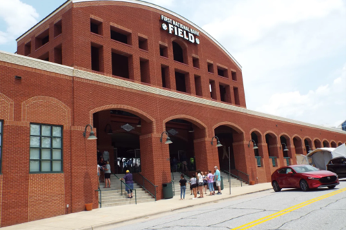
First National Bank Field
Greensboro’s downtown stadium opened its gates to a crowd of 8,540 on April 3, 2005 with a Grasshoppers exhibition game against the then Florida Marlins. This state-of-the-art facility features a 30′ wide, open-air concourse, plentiful concession points of sale, the Grandstand outdoor sports bar, a kid-safe play park and numerous amenities.
The stadium’s seating capacity currently stands at 7,499 which includes 5,300 chair back seats, 16 luxury suites and 2 grass berm and picnic areas, though the stadium was constructed to meet Class AA standards with room for expansion beyond. In March of 2017, the stadium was renamed First National Bank Field.
First National Bank Field plays host to numerous additional events each year, including the ACC Baseball Tournament in 2010 and 2012. On May 26, 2012, the University of North Carolina took on North Carolina State University in a game that broke the attendance record for a college baseball game in the state of North Carolina. The crowd of 10,229 was also the largest ever for an ACC baseball game!
Sandra Bradshaw Memorial
The June 1st 2009 crash of Air France Rio-Paris Flight 447 caused us to pause and recall a local airplane crash victim from eight years ago. As seen on the monument above, on September 11, 2001, Greensboro area resident Sandra W. Bradshaw died aboard United Airlines Flight 93. We want to remember the flight attendant from Greensboro who worked until the very end trying to help passengers on that ill-fated day. Several screens of information about United Airlines Flight 93 are available on Wikipedia, so we will defer to them for details.

This monument to Sandra is found just outside the baseball stadium in downtown Greensboro.
Source: Greensboro Daily Photo
Guardian II (Market St near Courthouse)
Guardian II is a huge metal sculpture which its creator (Billy Lee) deems “appropriate” for Greensboro. “As its title implies, Guardian II’s posture, stature and presence is like a keeper/guardian of the city,” Lee said. The Guardian II is located on Market Street in front of the Guilford County Courthouse.
International Civil Rights Museum
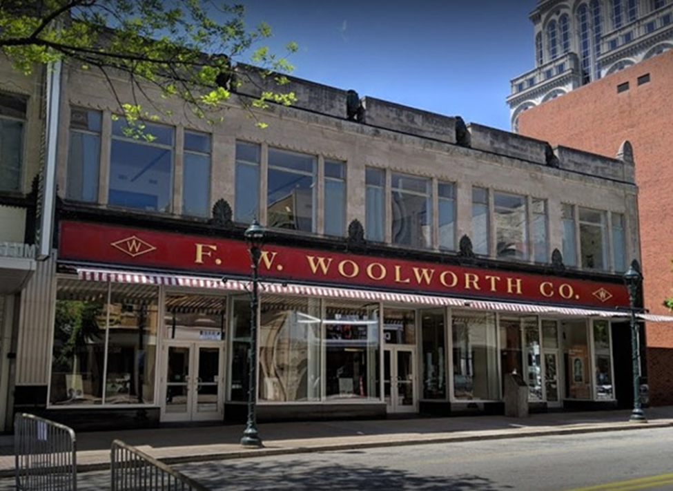
The building, built for Woolworth’s, opened in 1929. Like many other Greensboro buildings, it was designed by Charles C. Hartmann. It combines Art Deco, an elaborate style popular in that period, with classical elements. Notice the granite urns used as decoration along the roof line. This building gained international fame as the site of the February 1, 1960 sit-ins. On this date, four freshmen from nearby North Carolina A & T University, frustrated by the fact that African- Americans were allowed to shop in the Woolworth’s store but not to sit at its lunch counter, politely came into the store, sat at the counter, and asked to be served. Other students, including some from predominantly white colleges, joined the four young men (Ezell Blair Jr, now Jibreel Khazan; Franklin McCain; Joseph McNeil; and David Richmond). Today the building is the home of the the International Civil Rights Center & Museum.
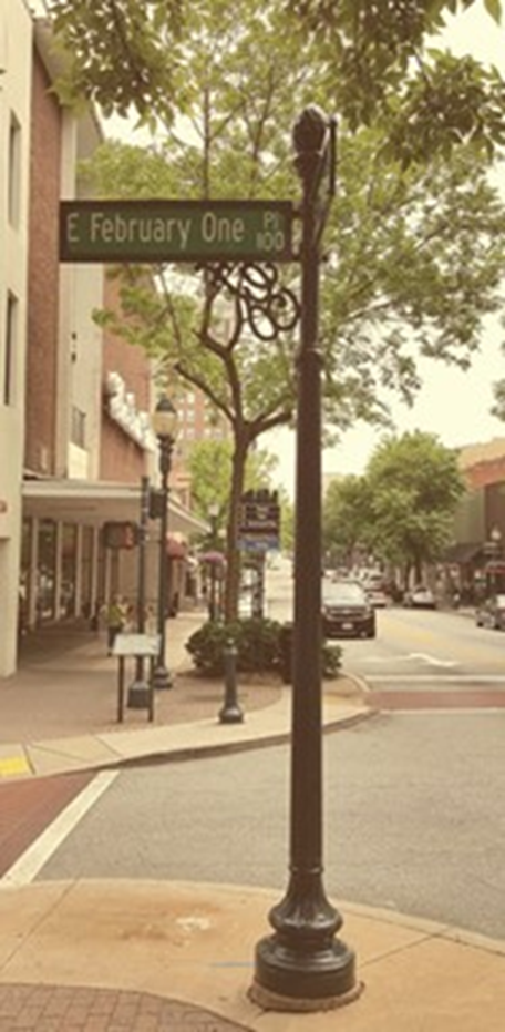
February One Place
This street running beside the Civil Rights Museum, honors the date of the Woolworth lunch counter sit-in in 1960.
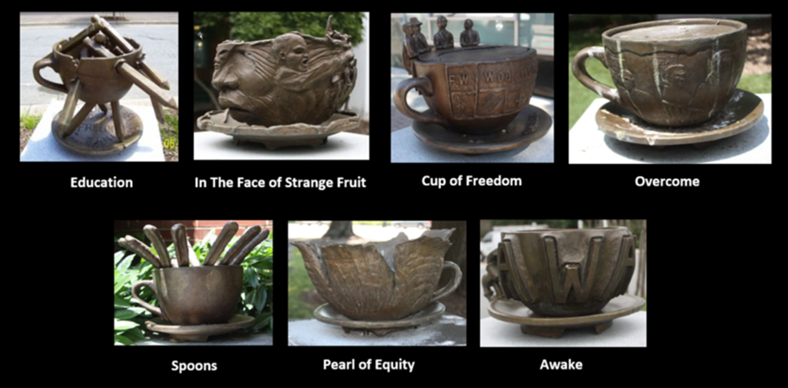
Greensboro Coffee Cups Collaborative
On February 1, 1960 the sit-in movement began. This historic event was commemorated by the creation of eight bronze coffee cups. Installed throughout downtown Greensboro and dedicated on the 50th anniversary of the inspired event when four African American students were refused service when ordering coffee, each bronze sculpture is placed on a stone pedestal, featuring the quote of an outstanding figure. The art project was a collaborative effort between The United Arts Council, The International Civil Rights Center and Museum, and Action Greensboro’s synerG Group. Each sculpture has a quote that demonstrates the courage of the four men who sat at the Woolworth lunch counter in 1960, starting the sit in’s.
The photo below shows all 7 cup sculptures. Both the long and short route for RunTheBoro 2023 Run #6 will pass several of the cups. The Cup of Freedom is beside the International Civil Rights Museum.
The Education Cup is one of the most notable sculptures of the project. It is a bronze cup pierced by pencils, symbolizing the oppression of black students in educational institutions. This sculpture includes a quote by Booker T. Washington: “I have learned that success is to be measured not so much by the position that one has reached in life as by the obstacles which he has overcome while trying to succeed.” The sculpture was created by Gregory B. Colleton Jr. and is located next to the Central Library on North Church Street.
In the Face of Strange Fruit was created by artist Derrick Monk, inspired by the Billie Holiday song Strange Fruit. The sculpture depicts the faces of those who struggled for freedom and equality. Included is a quote by Antoine De Saint-Exupery: “He who is different from me does not impoverish me – he enriches me.” The bronze sculpture is located on the lawn of the Greensboro Cultural Center on North Davie Street.
The Cup of Freedom, located next to the International Civil Rights Center and Museum on Elm Street, was created by Greensboro artist Charles Jenkins. On the pedestal is a quote by Dr. Martin Luther King, Jr. The last cup installed for the project, it was unveiled on the 50th anniversary of the famous sit-in movement, on February 1, 2010.
Overcome, a coffee cup created by artist Rodney Bennett, is located on the Melvin Municipal Building lawn on South Greene Street. The sculpture includes a quote by Ambrose Redmoon: “Courage is not the absence of fear, but rather the judgment that something else is more important than fear.”
Spoons: Of his sculpture, artist Leo Morrissey has said that the cup, spoons and persons’ profiles represent the sit-in movement, the students and their collaborative spirit against injustice. Included is a quote by John Fitzgerald Kennedy: “It is in the American tradition to stand up for one’s rights – even if the new way to stand up for one’s rights is to sit down.” This stone pedestal and bronze sculpture is located outside the Carolina Theatre on South Greene Street.
The Pearl of Equity is a cup shaped like a flower with a pearl on an oyster shell. The pearl represents the civil rights struggle, the shell the status quo, and the flower symbolizes spring and rebirth. Created by Greensboro artist Timothy L. Daniel, it is located on Hamburger Square on South Elm Street. A plate on the pedestal features a quote by Margaret Mead: “Never doubt that a small group of thoughtful, committed citizens can change the world. Indeed, it is the only thing that ever has.”
The Awake Coffee Cup, created by Kurt Gabriel, is meant to awaken the world from the deep sleep of indifference. Sculpted with large letters and a chain symbolizing bondage, it is located in front of the J. Douglas Galyon Depot on East Washington Street. The above information was obtained from Click Here. Here is a map for a walking tour of all the cups.
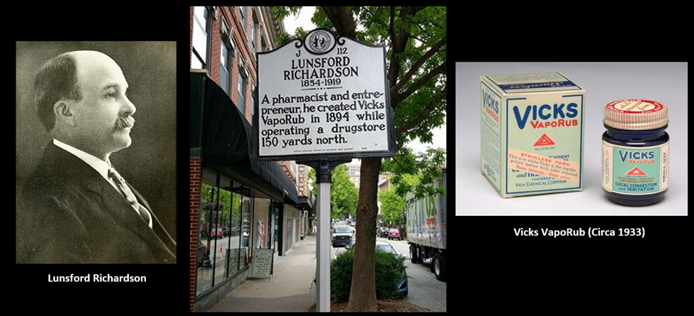
Vicks VapoRub?
New Bern, NC has claims to Pepsi Cola, but Greensboro is the birthplace of Vicks VapoRub! On this Saturday’s RunTheBoro run you’ll run close to this historic place near Washington and Elm. After graduating from Davidson College, Lunsford Richardson worked with his brother-in-law who owned Vick’s drug-manufacturing company in Selma, NC In 1890, Richardson moved to his wife’s hometown of Greensboro, where he bought W.C. Porter’s drug store with a partner. Nothing really special about this drug store although the famous writer O. Henry worked there as a teenager. During his time as owner of the drug store, Richardson continued developing new products for his brother-in-law’s company. He patented 21 medicines, including Vick’s Magic Croup Salve in 1894. Renamed Vicks VapoRub in 1911, the remedy is still sold today. The salve in the blue jar is made of menthol, camphor, oil of eucalyptus and several other oils, blended in a base of petroleum jelly.
Get this! Not only is Richardson credited with developing Vicks VapoRub, he’s also considered to be the creator of junk mail! Yep! Richardson was one of the first to market to post office box holders without personalizing the materials. (Information from the NC Department of Natural and Cultural Resources)
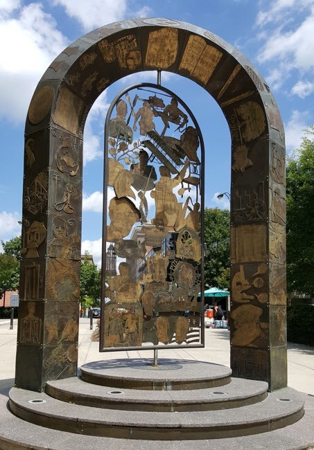
Millennium Gate, Greensboro (Greene St/ Feb One Pl)
Millennium Gate, unveiled in 2002, has become one of Greensboro’s most notable landmarks. Installed at the Municipal Office Building on West Washington Street, it was created by Jim Gallucci, a famous Greensboro artist. This bronze sculpture was inspired by the world’s greatest events, inventions and figures of the last millennium.
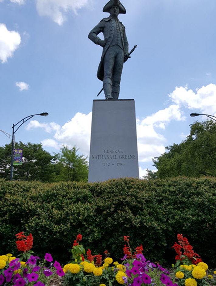
Nathanael Green Statue (McGee St/Greene St)
Nathanael Greene was a legendary major general of the Continental Army in the American Revolutionary War, and the person after whom the city was named. In an earlier RunTheBoro Run, runners ran along the historic Great Salisbury Wagon Road which is the road Greene travel to Guilford Courthouse for the infamous battle with the British.
This life-size bronze statue was created by artist Jim Barnhill and installed at the roundabout of Greene and West McGee Streets in 2008. A plate on the pedestal features a quote by Marquis de Lafayette: “In the very name Greene are remembered all the virtues and talents which can illustrate the patriot, the statesman, and the military leader.”
9/11 Monument (Elm St and Martin Luther King Jr Drive
This impressive monument to 9/11 was created by Greensboro Sculptor Jim Gallucci. The monument is made from steel beams recovered from the rubble of Twin Towers.
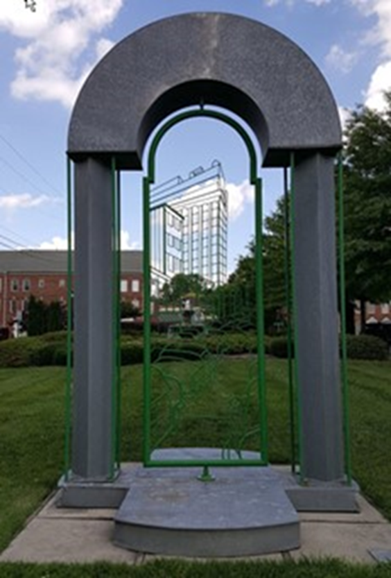
Downtown Gate Sculpture
The Downtown Gate is a sculpture located in Southside. The sculpture is by Jim Gallucci who created the News & Record Bench (relocated to LeBauer Park). The Downtown Gate depicts Elm Street during the late 1950s. It’s hard to see clearly in the photo below, but the sculpture depicts part of the Jefferson building and 1950 model cars parked along Elm Street.
The Gateway Center
Run #6 runners/walkers will pass the Gateway Center at Gate City Blvd and S. Elm Street. While a number of the structures from textiles’ golden era remain, too many, sadly, have fallen to development or are unsalvageable. The GATEWAY located at the corner of Gate City Blvd and S. Elm St. is unique, its structural integrity and character essentially unchanged from when it was opened in 1919.
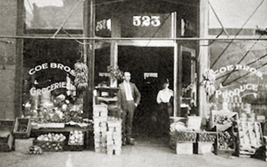
In 1897, A Tennessean named CC Hudson arrives in Greensboro to make his mark in the southern capital of textile manufacturing. In 1904, Hudson forms the Hudson Overall Company above Coe Brothers Grocery on South Elm Street.
In 1919, Hudson Overalls moves into the new Blue Bell factory at the corner of South Elm and Lee Streets.
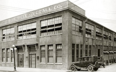
In 1943, Blue Bell acquires Wrangler Jeans and launches an era of international growth. In 1986, Blue Bell merges with VF Corporation. The original factory becomes multi-use commercial space called The Old Greensborough Gateway Center. In 2016, Andy Zimmerman buys The Old Greensborough Gateway Center and started renovations to become The Gateway Building.
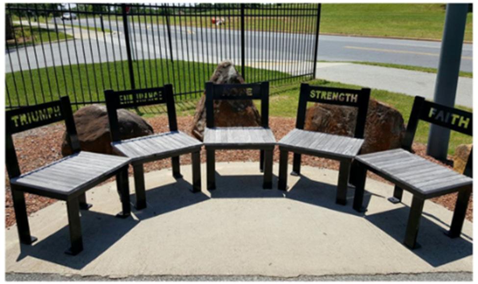
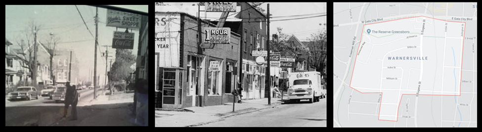
Warnersville Neighborhood Bench
The sitting area you see pictured below is the first of 12 neighborhood benches to be commissioned for the Downtown Greenway. The design reflects input from residents of the Warnersville neighborhood who attended a series of meetings held by the artist, Gary Gresko. Warnersville was once known as Five Points, and so the number 5 is repeated in his work The five words (Triumph, Endurance, Hope, Strength, Faith) etched into the back of each chair were chosen by the residence to describe the essence of their neighborhood and its history.
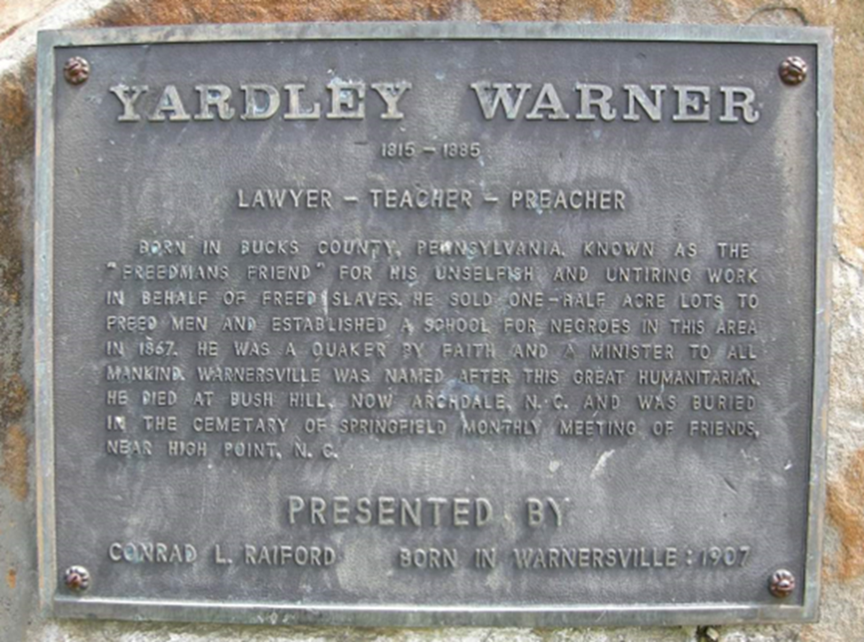
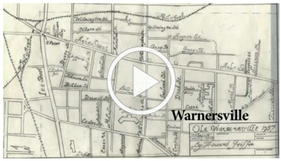
The Warnersville Community.
Warnersville is the oldest historically African American Community in Greensboro. In 1865, Yardley Warner, a Philadelphia Quaker, sold 35.5 acres of land to recently emancipated slaves who yearned for independence and home ownership. From it’s beginning, the community was started as a planned effort to promote black independence and self-help, and to sustain community pride. Warner hired Harmon Unthank, an ex-slave with a keen business savvy, to divide the property into lots and sell it. Unfortunately much of the buildings and architecture of the Warnersville Community was lost during the 1960 “urban renewal” when many were taken down making room for public housing. Below are pictures from a thriving Warnersville.
Below is a short documentary exploring the lingering impact of a mid-20th century urban renewal program on the residents of Warnersville, the historic African-American neighborhood in Greensboro, North Carolina. It is told through the memories of James Griffin, who was raised in the community and became a leader in preserving it’s heritage.
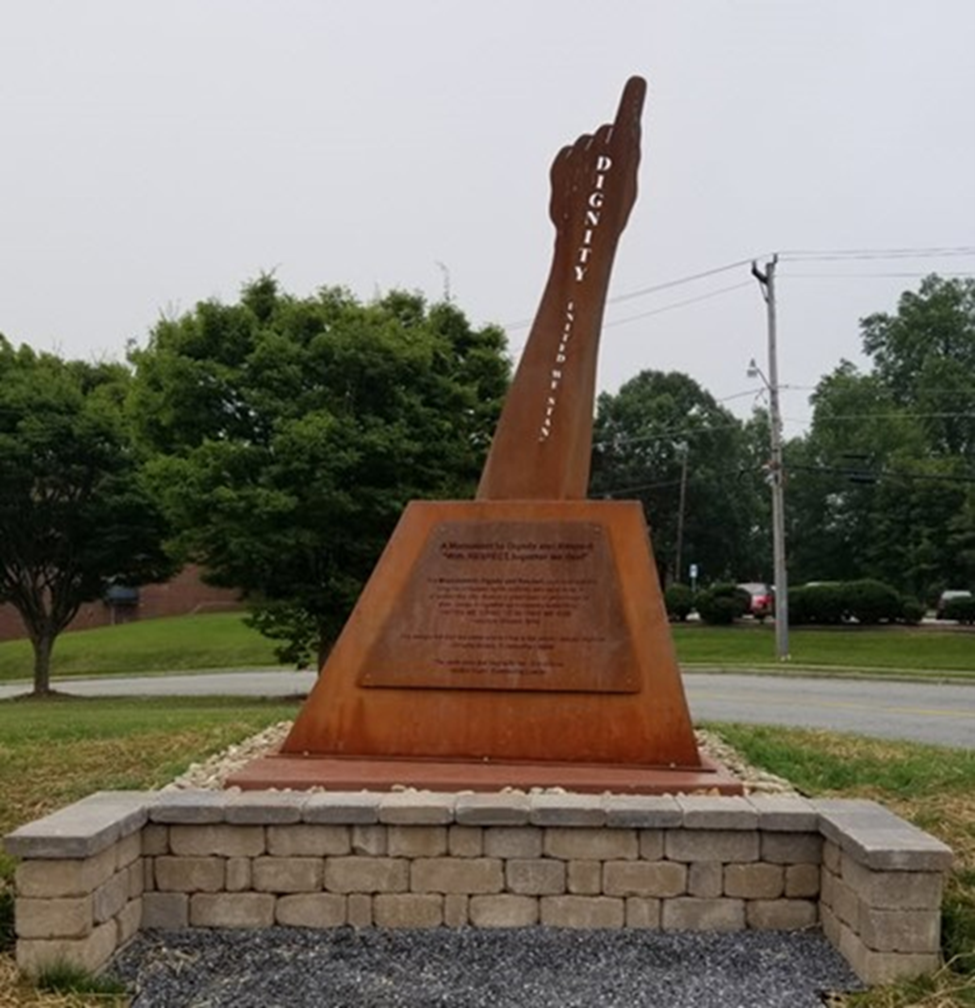
Martin Luther King Jr. Monument and the Dignity Monument
The city took down the Martin Luther King, Jr. bust of the sculpture for repairs, but it’s back and better than ever. It now sits on the corner of Martin Luther King, Jr. Blvd. and Bragg Street in Greensboro. To the right of the bust on the other side of the greenway you’ll see the Dignity Monument honoring a long list of human rights activists who have lived in and visited the city.

Freedom Cornerstone
This fourth and final Cornerstone commission is the Freedom Cornerstone. The theme of “Freedom” is inspired by the City’s role in the Civil Rights Movement, especially the non-violent protests of the pivotal 1960 Greensboro lunch-counter sit-ins that served as a catalyst to the larger movement. Racial justice and equity have played an important role in shaping our city and defining its identity. The selected artist is asked to explore this history as well as consider what Freedom means today as they conceive of a vision for the artwork. The site for this Cornerstone is located in the southeast corner of the Downtown Greenway’s four-mile loop – at the northeast corner of the intersection of Murrow Blvd and East Gate City Boulevard, Greensboro, NC 27401, a highly visible location that has been created with the realignment of the intersection as Downtown Greenway construction is underway.
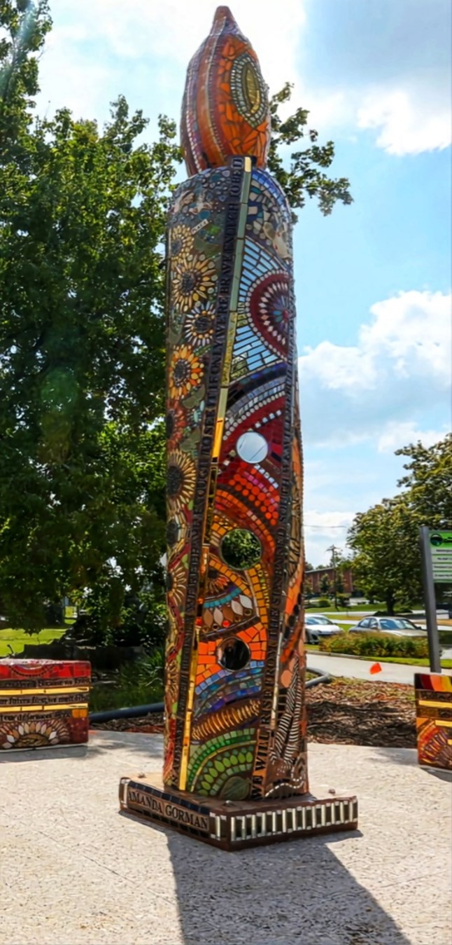
The Beauty of Vigilance
The Downtown Greenway’s newest public art piece was installed in August 2022, as the neighborhood bench for East Greensboro. Vigilance is located at the corner of Murrow Boulevard and East Market Street. The piece features a central candle column surrounded by three triangular benches, all adorned in mosaic work with colorful ceramics and mirrors. Created by artist Theresa Arico, the sculptures also include embedded verses throughout from Amanda Gorman‘s poem The Hill We Climb.
Theresa shares that mosaic is her favorite form of creative expression because it allows the use of both new and recycled objects to create a new vision and purpose. The ability to reassign value in cast-off objects that would typically contribute to the waste stream is important to her. Reinvention and second chances are important aspects of our human story as well. Theresa’s primary focus is creating or contributing to an environment that is nourishing and healing, and she hopes her work infuses others with hope, inspiration and passion. Theresa is based in Chapel Hill, NC and is an active member of the Orange County Artists Guild.
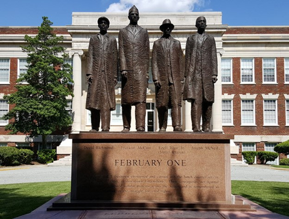
February One Monument (University Circle on NC A&T’s Campus)
On February 1, 1960 four African American students were refused service when ordering coffee at Woolworths on Elm St. The students were asked to leave by the store manager, but the students remained until closing time.
The next day, over twenty black students from surrounding schools including Bennett College, a college for black women in Greensboro, also joined. News reporters began covering the sit-in on day two. By day three the sit-in numbers grew to over 60 people. By day three, over 300 people participated and the sit-in expanded to the lunch counter at Greensboro’s Kress store. As the sit-ins continued, tensions grew in Greensboro. Students began boycotting stores with segregated lunch counters. Sales at the boycotted stores dropped by a third, leading their owners to finally stop their segregation policies
Considered the birth of the American Civil Rights Movement, the Greensboro Four are commemorated by this monument created by A&T art professor James Barnhill. Located at North Carolina A&T State University, this ten foot bronze statue was unveiled on February 1, 2002, depicting the Greensboro Four: David Richmond, Franklin McCain, Ezell Blair, Jr. and Joseph McNeil. A&T is a beautiful campus and I have to tell you, as I walked up to the the Greensboro Four it really made a statement to me. It’s a very powerful monument to visit in person.
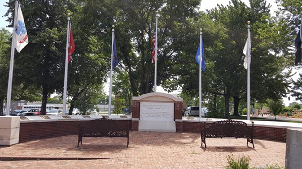
Veterans Memorial (E. Lindsay / Summit Ave)
The Veterans Memorial was built in 2014. As reported in a News & Recored article, 632 men and women who died in World War II and wars since, are memorialized at the downtown Veterans Memorial on plaques that once lined the walls of the old War Memorial Auditorium, which was part of the Greensboro Coliseum Complex but was demolished to make way for a 600-space parking lot.
The new downtown memorial plaza was built for about $90,000 and with the advice of veterans. It was designed with 3,000 bricks saved from the demolition of War Memorial Auditorium. The heart of it are the names — and a sign that reads in part: “Dedicated in 1959 to the memory of the men and women of Greensboro who gave their lives in the wars of our country.”
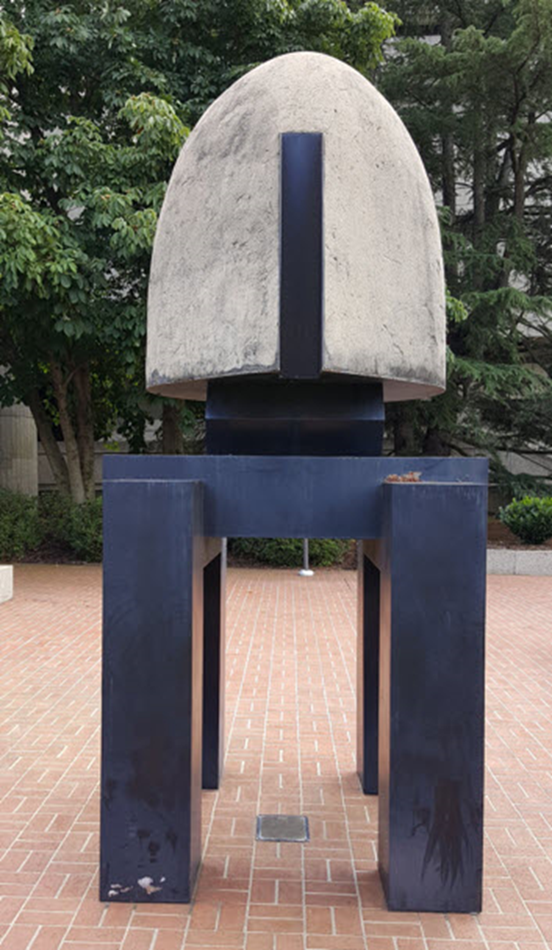
“Metaphor” by Ogden Deal (E. Lindsay / Summit Ave)
Located in the same plaza as the Veterans Memorial is Metaphor scuplure, a famous work by artist Ogden Deal, is a twelve foot steel statue of a human figure stretching out its hands to the sky. Standing for nearly forty years, the statue is sponsored by the Greensboro Youth Council and installed on Youth Square at the intersection of Summit Avenue, East Lindsay Street and Church Street.
Henry and Shirt Frye Monument-Center City Park
“Justice Frye has been a long-standing leader in many local non-profit, civic, academic, and professional organizations. After graduating from NC A&T State University, Justice Frye served our country as a member of the Air Force, with tours to Korea and Japan. After being denied the right to vote by way of the literacy test that was designed to prevent African Americans from participating in government decision-making, Justice Frye made a career change in an effort to abolish systemic racism across the state.
As a graduate of UNC School of Law, Justice Frye later became the first African-American elected to the North Carolina Supreme Court. His leadership would then propel him to serve as chief justice of the North Carolina Supreme Court in 1999.
Shirley Frye also graduated from NC A&T State University, and she has worked in various community and education positions in Greensboro for over five decades. As a former educator and assistant vice chancellor for development and university relations at A&T, Ms. Frye has committed herself to leading individuals of all ages to success. Ms. Frye retired as vice president of community relations at WFMY News 2 after winning an Emmy Ward, and she subsequently became the recipient of the Order of the Long Leaf Pine, North Carolina’s highest civilian award.”

Source: Greensboro Bar Association
O. Henry’s Book (N. Elm St / Bellemeade St)
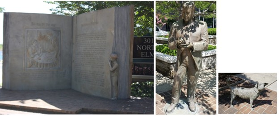
Located at 301 N. Elm Street, O. Henry’s Book is a huge 7 x 14 ft. tribute to the famous writer William Sydney Porter (better known as O Henry) who was born and lived much of his short life in Greenboro. The Gift of the Magi and The Ransom of Red Chief are the two stories depicted on its pages. Across from O. Henry’s Book is a life-size statue of O. Henry and his dog “Pete” The works were created by artist Maria J. Kirby-Smith and unveiled in 1985. A historical marker is located on Market St. between N. Edgeworth and N. Eugene marking the approximate birthplace of O. Henry.
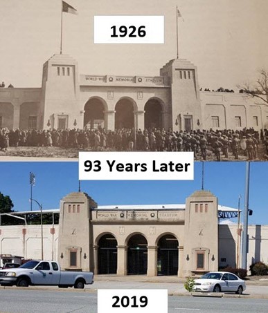
War Memorial Stadium (Yanceyville Rd) -Long Route
In 1925, the local American Legion post raised $100,000 in one week to build the stadium. It opened in 1926 in memory of soldiers who died in World War I. Due to the Greensboro trolley system in the 1920s and 1930, access to the stadium, even though it was away from town, was easy. It had one of the highest attendance for ball games of any stadium in the southeast.
Apartment Life (Early 1900’s)-Long Route
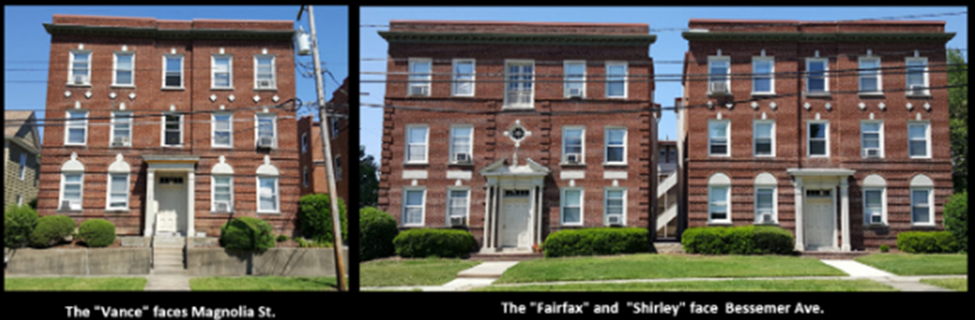
Many think of apartments as a fairly new concept, but Greensboro sported multi-story apartment buildings as early as the 1920s. Thanks to a central trolley line (more on the trolley’s in an upcoming RunTheBoro) and convenient urban location, in the early 1900‟s the Fisher Park neighborhood offered more apartments than any Greensboro neighborhood. RunTheBoro run #6 will take long route runners by three such complexes. The first complex runners will pass is located on the corner of E. Bessemer Ave. and Magnolia St. This 3-building complex (The Vance, Fairfax, and Shirley) was built in 1925. Some of the original features still exist such as exterior iceboxes. Three-story trash chutes are still used by residents today. An article in a 1925 edition of the Greensboro Daily Record, states that “the builders have taken care to install every feature that will delight the housewife’s heart. Every apartment has a built-in refrigerator, gas stove, kitchen cabinet , and hot and cold water, day and night. Janitor service will also be furnished. In one detail the owners are sure to make a hit with the housewife. They have put in window shades. Everyone who knows women is cognizant of the fact that they do detest the business of having to buy window shades and put them up.” The front apartments rented for $60 and the rear for $50 per month (this included gas, heat, hot and cold water, and janitor service.)
Hendrix Street Foot Bridge-Long Route
The Fisher Park and Dunleath neighborhoods are separated by a railroad track. Never fear…..RunTheBoro runners will traverse the awesome Hendrix St. foot bridge to cross over from Church St. to the Dunleath neighborhood.
Dunleath Neighborhood-Long Route
The Historic Dunleath neighborhood is located less than a mile northeast of downtown Greensboro Nestled between Church Street, Bessemer Ave. and Summit Avenue. The area holds two levels of historic district designation, both as a National Register Historic District designated in 1993 and a Locally Zoned Historic District designated in 1984. Historically, the area was home to many of Greensboro’s middle and upper class residents and this can be seen through the variety of residential architecture in the area. The majority of the neighborhood was developed in the late 19th and early 20th century and is named for the public middle school located along Cypress Street within the neighborhood. The neighborhood is also home to the World War Memorial Stadium, one of the nation’s oldest surviving minor league stadiums, and the Greensboro Farmer’s Market.
The neighborhood was originally named Aycock. The neighborhood board agreed to change the name to Dunleath. Neighborhood Board president David Horth says they put a poll out to neighborhood residents and others in the city asking them what name they wanted to see on the neighborhood and why. He said Dunleath had the most support. Dunleath refers to the estate of Robert Dick, considered to be the first person to settle in the neighborhood.
The neighborhood was originally named after Charles B. Aycock, North Carolina’s Governor from 1901-1905. He was known as the state’s Education Governor, but was also an advocate for white supremacy and segregation. Guilford County Schools recently decided to change the rename of Aycock Middle School after Melvin Swann. Swann was the district’s first deputy superintendent. Last year, UNCG removed the name Aycock from its Auditorium and Aycock St was renamed for civil rights trailblazer Josephine Boyd.
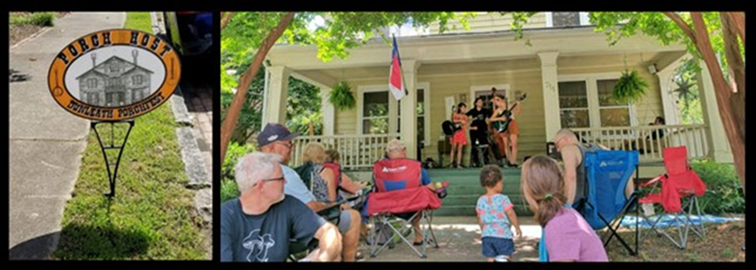
Porchfest
Taking place on Saturday, June 8 (11am-6pm) the Dunleath Porchfest is a unique event in which the community is invited to experience the hospitality of the Dunleath Neighborhood while enjoying the richness of performing artists in our community. Neighbors offer their porches as performance venues, and area performers offer to share their talents. Performances are held the neighborhood, and guests can stroll from house to house enjoying community goodwill in a festival-like atmosphere. This family-friendly event culminates in a single performance at Sternberger Park to conclude the event. Admission is free and all are welcome. There will be food vendors, free activities for kids, event t-shirts, and to generate even more community goodwill, we collect canned goods for a local food pantry. For more info click here.
East Greensboro-Long Route
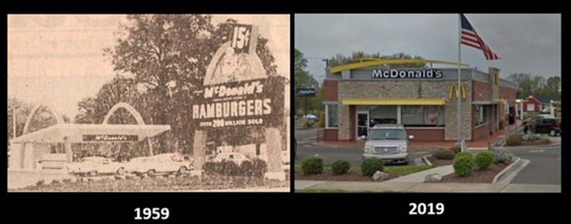
Did you know the very first McDonalds in NC was built in East Greensboro? Yep! One of Greensboro Many Claims to fame. On September 30, 1959, the first McDonald’s Restaurant in North Carolina opened at 1101 Summit Avenue in East Greensboro. RunTheBoro Run #6 long route runners will pass this location on their run. 60 years later, there is still a McDonalds at that location (albeit a more modern Version.)
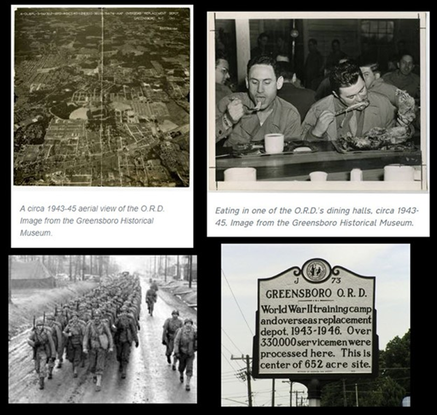
Did you know that Greensboro was home to a World War II Military Base? Sure was! On March 1, 1943, the U. S. Army Air Force opened a training base near the intersection of Summit and East Bessemer avenues in Greensboro. At 652 acres in size, it was the largest base in America located within the boundaries of a city. Placing the soldiers within walking distance to Greensboro businesses, Basic Training Camp Number 10 boosted the economy and the morale of trainees. The base operated in this capacity for fifteen months, during which time about 87,000 men and women prepared for the Air Force.
By May 1944, the Air Force had reached its projected capacity and the base became part of the Army Air Force Personnel Distribution Command. The Greensboro facility became the primary eastern Overseas Replacement Depot (O.R.D.), where soldiers were prepared and processed for overseas duty. In February 1945, the site’s responsibilities were altered again. At that time it took on added duties as Redistribution Station Number 5. In that role, it placed about 31,000 troops in the Far East as fighting shifted. Just after V-J Day, in September 1945, the station began processing personnel for separation from duty. Thus, during its period of service, the Greensboro depot provided services ranging over the full cycle of military duties. Over 330,000 troops were processed in or out of service or redistributed to another location through the center.
As many as 40,000 soldiers were stationed at the Greensboro facility at any given time. The base was comprised of 964 buildings, including five hundred barracks, fourteen mess halls, fifty-five recreation rooms, four movie theaters, ten PXs, five chapels, three libraries, and an equal number of gymnasia, and one large base hospital. Headquartered at the hospital were a newspaper and a radio station, both geared toward entertaining the troops in the Convalescent Training Program. The Greensboro base was closed September 15, 1946, and declared surplus eight days later.
There is a historical marker on Wendover that marks the approximate center of the base.
References:
(Raleigh) News and Observer, January 24, 1994;
Greensboro News & Record, April 14, 2003;
“Greensboro ORD: Its Past and Present,” contemporary report from the base on file in Research Branch, North Carolina Office of Archives and History
Did you know that Greensboro’s first drive and park shopping center comprised of multiple stores was built on a section of where the WW II military base stood? Yep! While on Summit, just before runners reach Bessemer Ave., they’ll see a shopping center on their right. In 1950, Summit Shopping Center opened in the area that had been a World War two army base. This was Greensboro’s first (and NC’s second) center-based shopping area with a new concept of parking your car and walking to numerous stores in one complex. Friendly Center did not open until 1957.
Run #5
Revolution Mill, White Oak “New Town” Mill Village, McAdoo Heights, Brown Town, Loewenstien House, Kirkwood, Lustron House, Old Irving Park
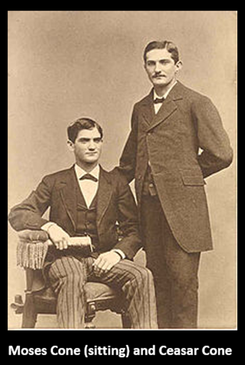
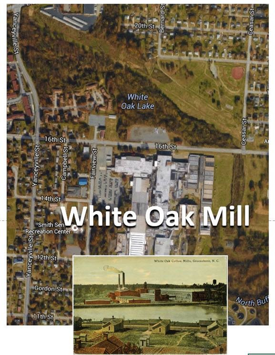
Did you know that the swanky Proximity Hotel and upscale restaurant Print Works on Green Valley Road were named after two of the four Cone Mills in Greensboro? On the RunTheBoro Run #5, runners will run between two of the 4 mills (Revolution Mills and Proximity Mills) while running down Yanceyville St. Cone Mills was founded by Moses and Ceasar Cone. In 1895, the Cone brothers constructed a denim mill on land they owned in Greensboro, North Carolina. Since the plant was near its supply of raw materials, the cotton fields of the South, the Cones named their new factory the Proximity Cotton Mill, and set up a holding company for this plant and the others in which they held an interest called the Proximity Manufacturing Company. In 1896, the first lengths of fabric rolled off the big looms at Proximity. Ceasar Cone felt that denim, a sturdy fabric for use in work clothes, would be in constant demand as the United States expanded and industrialized.
In1899, the Cones opened Revolution Mills, a modern facility to weave soft cotton flannel. In 1902, a second denim plant was under construction. Called White Oak, it was named for the enormous tree that grew on its site. With ten different warehouses for cotton and its own power plant, the mill began turning out indigo blue denim by 1905. A fourth mill, the Proximity Print Works, was built in 1912. It was designed to “finish” or print cotton with multiple colors, creating a type of cotton product new to the South. The Cones built 5 mill villages for the workers to live in.
Mill villages were company-owned towns, built from scratch by textile mills to house their factory workers and their families. In the early 1900s, Cone Mills Inc. built five villages (Proximity, Revolution, White Oak, White Oak New Town, East White Oak) to serve its Greensboro factories. RunTheBoro Run #4 will run through White Oak New Town which was listed on the National Registry of Historic Places in 1992 These villages included churches, schools, ball fields, community centers, and company stores. Thousands of workers and their families made their lives in these “towns within a town” until the company began selling the houses (sometimes to workers) in the late 1940s. Check out the great History Timeline at the Revolution Mill website.
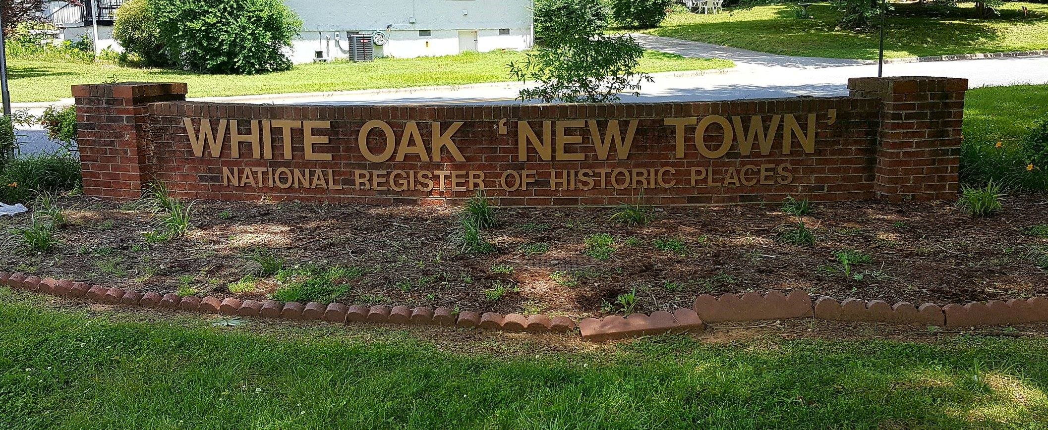
White Oak “New Town”
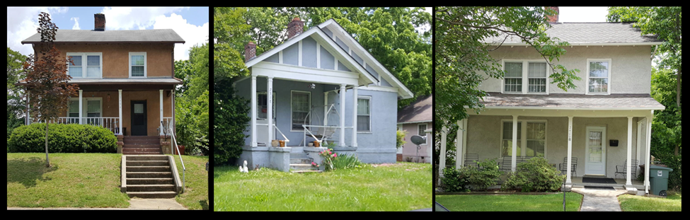
Did You know? There is an almost intact mill villlage in Greensboro? During the first mile of RunTheBoro Run #5 runners will get to run through this historic site. Tucked away on the other side of Church St. Across from Ceasar Cone Elementary School is the White Oak “New Town” mill village. The village was listed on the National Register of Historic Place in 1992 . The White Oak New Town Historic District is exceptionally intact. All of the one hundred hollow-tile walled, one- and two-story, stuccoed houses built there by the Cone family’s Proximity Manufacturing Company about 1920 survive. Sixty-four car sheds, erected by the company in the late 1920s, continue to bracket the alleys that parallel the district’s regular grid of streets. All of these buildings contribute to the integrity of the White Oak New Town Historic District. Only three small, frame, one-story classroom buildings (erected at 2507 and 2509 Hubbard Street and 2504 Cypress Street), removed after the 1935 construction of the Ceasar Cone Public School just west of the district, are no longer extant. The houses still stand on the same small lots in the same relationship to the car sheds, streets, alleys, and each other as they always have. All but two are still stuccoed and their exteriors have been little altered. For more info on the village go to http://www.livingplaces.com/…/White_Oak_New_Town_Historic_D…

Life in the Mill Village
What was life really like in these towns within a town? From what I’ve read, work in the mills was hard and dangerous. The workers didn’t get paid much and the goods sold to them in the village stores were overpriced. If a worker lost his job, he lost his house. It was a hard life. But one thing, I found underlying all the stories I read was that there was a strong sense of community and support among the villagers. Below are links to audio clips of people who lived in the Cone Mill Towns sharing their memories about life in the Mill Town. When I did the RunTheBoro Run #5 test run through the White Oak “New Town” area I could hear these people (sharing below) in my head and see them standing on the stoop or sitting on the portch.
Listen to Helen Thornbro talk about the teenage club above the company store. Click Here
Listen to Brenda Zeigler talksabout visiting the drug store on Thursday nights while waiting for the boys to get out of the Boy Scouts meetings across the street. ClickHere
Somewhere on 16th Street, Larky Johnson’s grandfather used to decorate for Christmas. Click below to hear Larky describe the unique decoration he used. Click Here
Listen to Leroy Paris tell a great story about the White Oak Mill whistle blowing at the wrong time. Click Here
Listen to Kenneth Brady discuss the significance of baseball in the Revolution village. Click Here
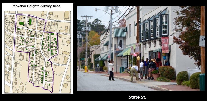
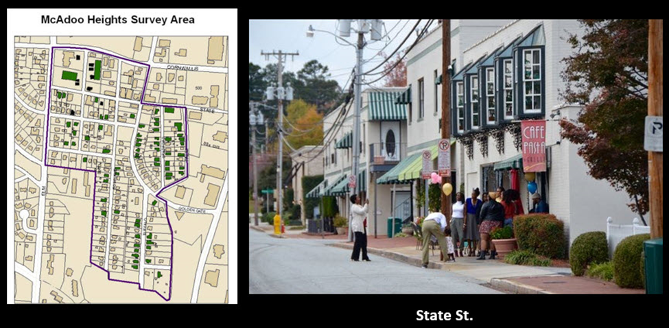
McAdoo Heights
McAdoo Heights was one of the earliest residential and commercials districts of Greensboro. It was often called a “Town within a City.” It got this name because of the many businesses in the area which catered to the residents of the surrounding Cone mill villages such as White Oak New Town. McAdoo Heights was developed in the early 1900s. The area thrived through the 1930s. It provided restaurants, pharmacies, apartments, churches, hardward stores, and even a theater. The neighborhood had ists own police officer and school. According to a News & Record article, some who did not live in the area, thought it to be an unsafe place because of its rowdy bars and smoky pool halls. But as the article shared, the people who lived there remember it as a close-knit community where everyone helped one another. There was a restaurant, Mashburn’s Cafe that everyone referred to as “Pop’s” that was the popular place for residents to hangout.
People began to move a way in the 1960s and the theater began playing X-rated movies and decline set in. People began shopping at newly built Friendly Center in 1957 and later (1974) Four Seasons Mall. In 1983, the shops on State St when through a major rennovation. Developers John Harmon and Lynn White created a village shopping district with French architecture with striped canvas awnings and brick sidewalks. The newly transformed business district was upscale and people once again began to return to McAdoo Heights. This lasted for about 20 years before merchants began to struggle in the mid to late 2000s when the economy tanked. There are still awesome shops, restaurants and businesses on State Street. You should check it out!
Browntown
RunTheBoro Run #5 long route runners will turn off of W. Cornwallis Dr. into a little known neighborhood called Browntown. The Browntown neighborhood is located at North Elm at Cone Boulevard and backs up to Kirkwood and Irving Park.* This part of town is called Browntown because it was developed by the Brown Corporation- in the 1950’s. Although built at the same time as the other houses in the neighborhood, this house shown has more of a modern take on the 1950s style.
Loewenstien House
Architect Edward Loewenstein moved to Greensboro in 1945, after marrying Frances Stern, the daughter of a prominent Greensboro family. He established a design practice and then partnered with Robert A. Atkinson Jr. in 1953, becoming a local leader of modernist design. Over three decades, Loewenstein and Atkinson completed 1,600 commissions, including Loewenstein’s own residence, a masterpiece of modern architecture set in a two-acre wooded suburban lot approximately three miles north of downtown Greensboro, located at 2104 Granville Road. Runners will pass the house just after turning off Cornwallis Road onto Granville.. It is surrounded largely by Georgian and Colonial revival structures, some of which date from the 1920s.
The Loewenstein House exhibits many characteristics of midcentury modern design: a single-story, open floor plan that stretches out horizontally on the site; flat and low-sloped roofs; large expanses of windows; an informal relationship to the street; and connections from the inside spaces to the surrounding landscape.
Loewenstein became a significant figure in Greensboro not just for the infusion of modernism to the landscape of the city, but also because of his progressive ideas. Loewenstein taught at the University of North Carolina at Greensboro, then known as the Woman’s College of the University of North Carolina. A house designed by his class of twenty-three female interior design students in 1958 was profiled in McCalls magazine. This course for “college girls” was intended to “demonstrate actual planning, design, construction, and finishing of a home.” It was hailed as “a unique project … an educational first!” for a profession that was largely dominated by men. Loewenstein was familiar with pushing social norms. Loewenstein and Atkinson was the first white firm in Greensboro to hire African American architects and design professionals, among them William Streat (Loewenstein’s MIT classmate) and W. Edward Jenkins.
Today, the house is occupied by the architect’s daughter, Jane Loewenstein Levy. It is a private residence that is not open to the public.
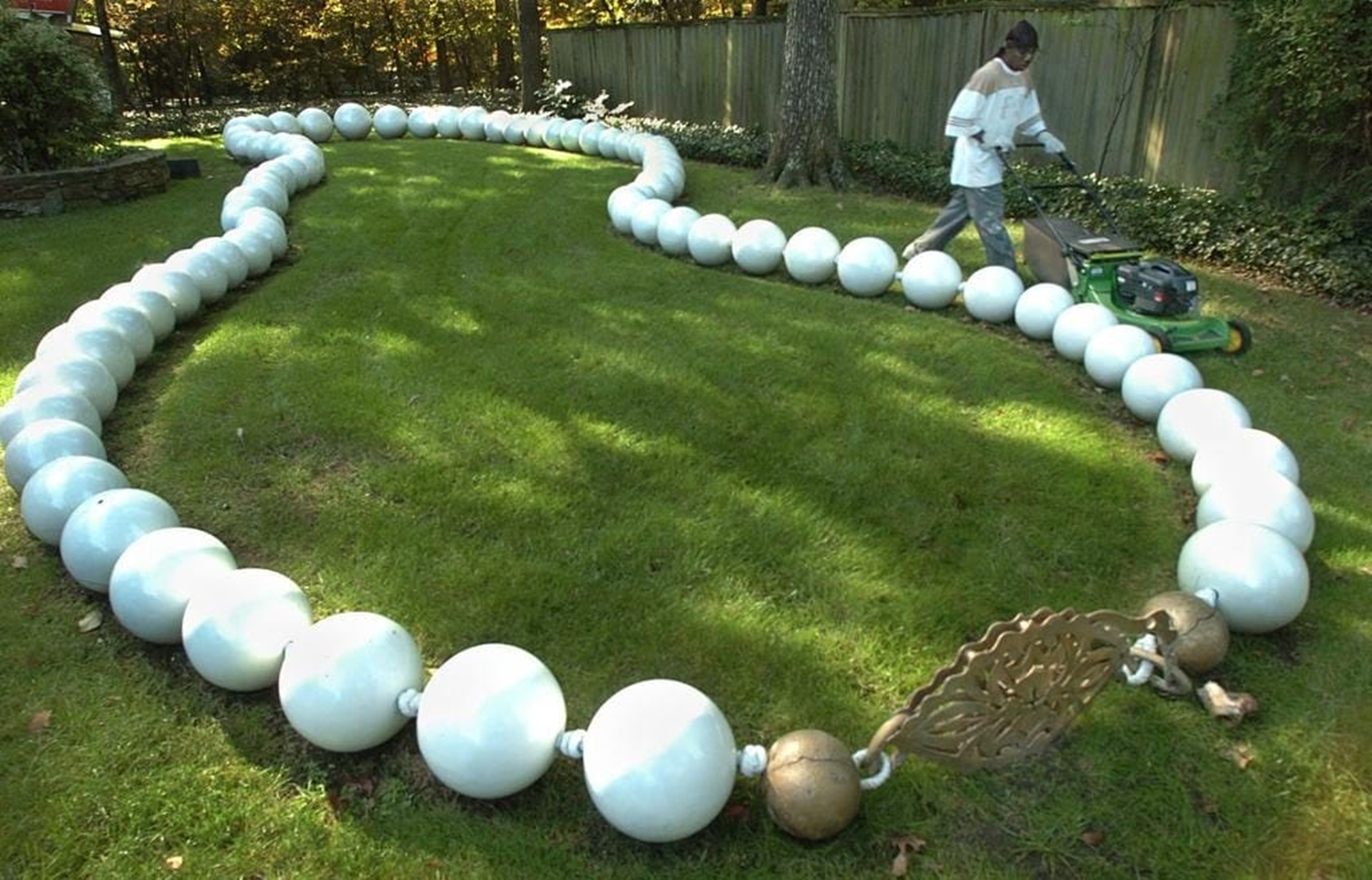
The house is also home to a pretty cool sculpture garden. One sculpture is made from recovered airplane part and if you look carefully, you’ll see a giant pearl necklace sculpture!
Kirkwood
One of the first neighborhoods runners will run through on the 5th RunTheBoro run/walk is Kirkwood. The Kirkwood Community began as two farms that were purchased and developed on the outskirts of Greensboro in the 1920s. The Kirkpatrick farm homeplace was located at current 906 West Cornwallis and the Holt farm homeplace was located at current 2000 Dellwood Drive. The Holt Farm property was sold and developed into residential lots in the 1930s, and Kirkpatrick Farm property was developed for postwar housing in the late 1940s and early 1950s. The majority of these hundreds of houses were small and built on deep narrow lots approximately 60 years ago. A few newer streets were developed with larger houses on larger lots in the late 1950s through 1990s,At the request of the Kirkwood Garden Club in the early 1950s, the City established Kirkwood Recreational Park (which the RunTheBoro runners/walkers will pass) is part of the City’s park system. Since that time the entire surrounding neighborhood has enjoyed the recreational equipment and the Parks and Recreation Department’s summer programming.The annual Kirkwood 5K (which is a fundraiser for Backpack Beginnings) starts and finishes at Kirkwood Park.
Lustron Home
Carl Strandland, asked President Truman’s Reconstruction Finance Committee (RFC) in the summer of 1946 for $15 million worth of emergency loans to build small houses for GIs returning from the war effort. Strandland was not an architect, but his idea that metal neighborhoods could be prefabricated and swiftly built persuaded the President’s Commission into signing the loan 15 minutes before its emergency powers expired, and the “Lustron” was born.
To manufacture the ten tons of steel that went into each two-bedroom Lustron, Strandland bought a 25-acre factory lot in Columbus OH which had been used during WWII to build fighter planes. Strandland went back to the government for two more loans totaling another $25 million. A few years and only about 3,000 Lustrons later, the company was repossessed by the RFC in February of 1950 and declared bankruptcy a number of months later.
There was a three-bedroom model along with the two-bedroom Westchester. Lustron also made a smaller Newport model in both two- and three-bedroom versions.
Approximately 2,500 of the homes were produced at a cost of approximately $7,000. They were designed to be maintenance free as well as rodent, fire, rust, and lightening proof! They were originally sold in blue, blue-green, gray, tan, and yellow, the common colors, and green and pink, the rare colors.
According to the data base of the Lustron Registry, this house at 2302 Lawndale Drive is one of less than 200 blue Lustrons remaining. It is one of two remaining in Greensboro. A gray one is on Delwood Drive, also on the borders of Kirwood and Irving Park neighborhoods. A gray one on Myers Lane was torn down in 2000. At last count, thirty nine remain in North Carolina.


Old Irving Park
Irving Park is one of the oldest neighborhoods in Greensboro. In 1909, John Nolen, who headed a national landscaping firm in Cambridge, Mass., created the Irving Park neighborhood. The houses and mansions border the neighborhood center piece, the Greensboro Country Club golf course, which was founded the same year as the neighborhood. When Irving Park was expanded, Robert Cridland of Philadelphia completed the job. According to the National Register of Historic Places Registration Form, houses in most areas were to cost at least $5,000 (in 1912). I think they’ve increase a tad since 1912. Irving Park has remained the city’s premier neighborhood for more than 100 years. Cridland also designed the grounds of A.W. McAlister’s mansion on Country Club Drive, the still-magnificent courtyard of the Country Club Apartments (now condos) and the enormous grounds of what was from 1924 to 1990 the headquarters of Pilot Life Insurance Company in Sedgefield. Whilerunning on the Latham Park Greenway, In 1995, Irving Park was placed on the National Register of Historic Places by the United States Department of the Interior. That’s pretty cool!

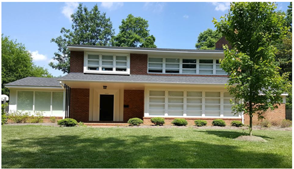
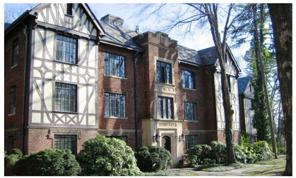
The beautiful house below is known as the McAdoo-Sanders-Tatum House and is located at 303 Wentworth Street (both routes for RunTheBoro run/walk #5 will pass this house). It’s recognized as a Guilford County landmark property. This house may also be the oldest home in Irving Park. Construction dates (for the stately home) are not certain. Many aspects of the home put it being build around 1890, but other evidence speaks to an earlier farmhouse that may have been on this very spot. This land the home is on was purchased by Colonel Walter D. McAdoo in 1890. McAdoo was a prominent Greensboro resident who built and operated the McAdoo Hotel (built in 1870) which was located on South Elm Street. The supposed farmhouse may have been a retirement retreat for McAdoo. No one knows for sure, but the bigger home may have been constructed absorbing the farmhouse. Hard to believe that stately Irving Park was once considered rural farmland by Greensboro residents.Below the house picture you’ll see a picture of the impressive McAdoo Hotel once located at 301-311 S. Elm St. The hotel was build in the late 1800s. It was destroyed by a fire in 1915. A new hotel was planned, but an office tower (The Guilford Building ) was build in 1927 instead.
How many times have you passed the stately Irving Park Manor (shown below) while running or driving down Elm Street? Ever wondered about it’s history? Did you know it has a connection to the White House? Yep, that’s right, the White House as in Pennsylvania Ave. White House.
According to Preservation Greensboro, a young man by the name of Lorenzo Simmons Winslow had a hand in quite a bit of architecture found in several of our historic neighborhoods and downtown, including the iconic Irving Park Manor Apartments built in 1929. When the apartments opened they were exclaimed as “North Carolina’s finest” and were quite modern for the time including modern amenities such as electrical refrigerators, electrical stoves, electrical dishwashers, wiring for radios, and colored enamel bathrooms. Winslow is also responsible for many of the unique homes found in the Sunset Hills neighborhood.
During the Great Depression, the housing and building industry suffered greatly in Greensboro, and so Winslow took on government work to fill the gap. This change took tim to Washington DC where he began to work for the Office of Public Buildings and Public Parks of the national Capital. With this position he worked on many notable structures including the Statue of Liberty and the Washington Monument, bridges and roadways in Washington’s Rock Creek Park. Then Winslow entered a competition for the design of a swimming pool that was to be added to the White House. The heated pool was needed so that President Franklin Delano Roosevelt could practice a regular swimming routine as therapy for his polio affliction. Winslow won the competition and Roosevelt praised Winslow’s work, stating in a letter “I have just examined the new swimming pool and dressing rooms, for which I am informed you did the architectural work. Allow me to commend you for the excellent taste you have exhibited in your selection of colors, materials, and proportions. The whole result is most harmonious and agreeable to the eye. I appreciate your efforts. Very sincerely yours, Franklin D. Roosevelt”
Winslow remained on staff with the White House for the next 20 years, supervising increasingly significant alterations to the People’s House. He became somewhat of a celebrity inside the beltline, profiled occasionally by columnists and national magazines. He gained a reputation for his partiality to tweeds, his love of the arts, his signature corncob pipe, and his ancient car. For more information on Winslow Greensboro history be sure to visit Preservation Greensboro.
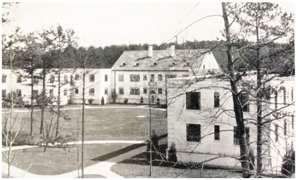
Just past Irving park Manor, is an impressive set of white brick buildings on their left. Today, this impressive complex is known as the Country Club Condominiums, however, they began as apartments. According to Preservation Greensboro, they were erected in 1937, and were the first “garden-style” apartment complex in the city. The apartment complex was privately financed by investors Julian Price, then president of Jefferson Standard Life Insurance Company, and Emry Green, then president of Pilot Life Insurance Company to address a community housing shortage. The George W. Kane Construction Company erected the $525,000 project that was heralded as the “largest apartment house in North Carolina” at the time, and set the stage for a new generation of apartment design in Greensboro.Below is an early picture of the Country Club Apartments. For more information on the Country Club Apartment go to Preservation Greensboro.
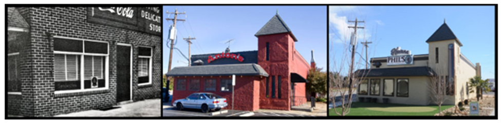
At Battleground and Northwood, the long route runners will see Havana Phil’s. Many of you probably remember this building as the home of Anton’s restaurant. According to Images of America: Greensboro Volume II Neighborhoods, by Gayle Hicks Fripp, The building was purchased in 1962 by the Anton brothers. Did you know that prior to Anton’s, the building was home to the Irving Park Delicatessen that was owned by Ernest Kahn and Ernest Katz. Fripp states that by 1950, the Irving Park Delicatessen was a one of Battlegrounds best known attractions. The delicatessen has limited inside seating and a take-out window. When the Anton brothers bought the building, the added a full restaurant in the basement of the building known at Cellar Anton’s.
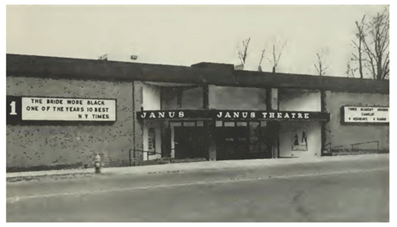
While on Northwood, the long route runners will see the tall multi-story traditional First Citizens Bank building. This location was originally the home of the Janus Theatres. According to cinematreasures.org, the Janus Theatres in Greensboro North Carolina opened its doors to the public on December 20, 1968 as a twin theatre. It was the South’s most elegant theatre and it was the second twin theatre to open in North Carolina. At the time of its opening the Janus 1 & 2 was one of the first modern ultra theatres in the South between Washington and Atlanta to have full automated projection and stereophonic sound. The first films shown were “Yellow Submarine” and “Elvira Madigan”. By 1970 it expanded to four screens and by 1975 three more screens were added to expand to seven screens. By 1981, it eventually grew to eight screens and was Greensboro’s top entertainment showplace when it closed in 2000. It was demolished to make way for luxury condos and speciality shops. The shops and condos never happened and the bank was erected instead. The Janus Theatres showed many first-run blockbusters and well as smaller independent and art films, as well as special features of interest. Below is an early picture of the Janus Theatres.
Run #4
Delwoods Park, Guilford Hills, Garden Homes, Westwood, Lawndale Homes*, New Irving Park* Brookwood Gardens* (*Long Route)
Guilford Hills, Garden Homes, Westwood
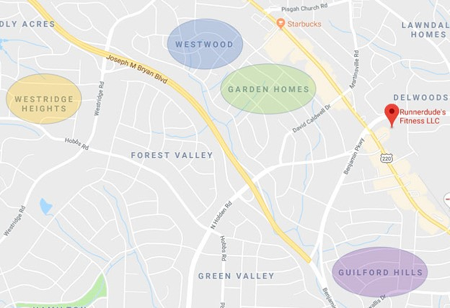
Guilford Hills, Garden Homes, and Westwood Neighborhoods
You might not know this neighborhood’s name, but if you’ve been to the old Women’s Hospital, the new Aldi, the Elks Club or Starbucks, then you;ve been been to Guilford Hills, Garden Homes and Westwood. Guilford Hill is the area just west of Battleground Avenue and north of Green Valley Road. The northern border is David Caldwell Drive and the westernmost street is Benjamin Parkway/Bryan Boulevard. Guilford Hills is actually less than one square mile and has less than 2,000 people living in it. Many of the homes in this neighborhood were built in the 1950’s and 1960’s. An older, Greensboro Daily Photo reader once shared that he used to ride horses on his friend’s farm in Guilford Hills. Can you imagine that less than 70 years ago this area was farmland?
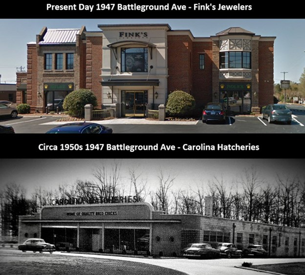
Times certainly do change the landscape. Did you know that back in the 1920s-early 1970s there was a hatchery “Carolina Hatcheries” at 1947 Battleground Ave (corner of Battleground Ave and Cornwallis Dr. )? Yep, according to Images of America: Greensboro Volume II Neighborhoods, at the southern border of Guilford Hills neighborhood and the location of today’s vacant Fink Jewelers, once was a hatchery. This Saturday’s RunTheBoro won’t be running past this location, but next time you pass through the intersection of Battleground and Cornwallis, remember it used to be a hatchery!
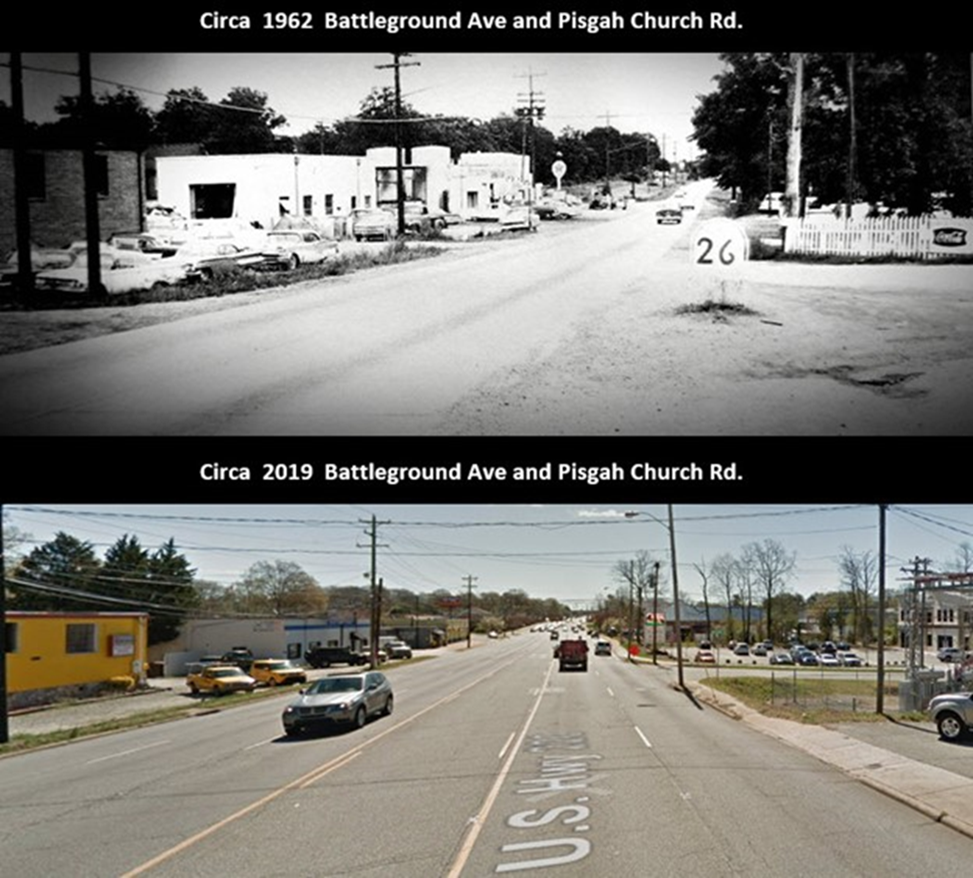
In 1962, the picture below shows what the area near the intersection of Battleground Ave and Pisgah Church Rd looked like. If I’m not mistaken, the road in 1962 is dirt. The view is looking south down Battleground Ave. Mt. Pisgah Church could be found on the left (1962 and 2019) and today, Lowes is located on the right. Between this intersection and the Cone Blvd intersection, the Garden Homes subdivision was created in the 1950s.
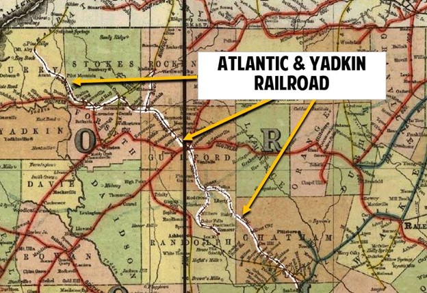
Atlantic and Yadkin Greenway
RunTheBoro Run #4 runners will run this Saturday along still another stretch of the Atlantic & Yadkin Greenway.
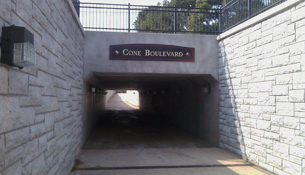
Did you know…that this stretch of greenway is the former rail bed of the Atlantic & Yadkin Railroad? The Atlantic-Yadkin Railway’s lifespan covered 1899 to 1950, but some of the rails were laid in the 19th century as part of the Cape Fear and Yadkin Valley Railway (CF & YV). The CF & YV ran from the Atlantic port of Wilmington, NC to Mount Airy. This railway transported mostly granite and at one time took travelers to visit the Guilford Courthouse National Military Park. Runners and walkers will pass through a tunnel that runs under Cone Blvd. As you run through that tunnel take a look at the walls leading into and out of the tunnel. They’ve been crafted to look like granite blocks in homage to the granite transporting Atlantic and Yadkin Railroad. There is also a mural on the interior walls of the tunnel that includes a painting of a train. Look closely at the train patining and you’ll notice it’s carrying granite blocks. This is all to honor the history of the Atlantic & Yadkin Railway and its importance to Greensboro.
Run #3
Atlantic and Yadkin Greenway, Guilford Battleground Military Park, Old Salisbury Wagon Road, Country Park* (*Long Route)
Atlantic & Yadkin Greenway
RunTheBoro Run #3 runners/walkers will run along a short stretch of the Atlantic & Yadkin Greenway.
Did you know…that this stretch of greenway is the former rail bed of the Atlantic & Yadkin Railroad? The Atlantic-Yadkin Railway’s lifespan covered 1899 to 1950, but some of the rails were laid in the 19th century as part of the Cape Fear and Yadkin Valley Railway (CF & YV). The CF & YV ran from the Atlantic port of Wilmington, NC to Mount Airy. This railway transported mostly granite and at one time took travelers to visit the Guilford Courthouse National Military Park. Further south on the greenway there is a tunnel that runs under Cone Blvd. Next time you run through that tunnel take a look at the walls leading into and out of the tunnel. They’ve been crafted to look like granite blocks. There is also a mural on the interior walls of the tunnel that includes a painting of a train. Look closely at the train and you’ll notice it’s carrying granite blocks. This is all to honor the history of the Atlantic & Yadkin Railway and its importance to Greensboro.
Currently the Atlantic & Yadkin Greenway begins at Markland Rd (behind the target shopping center on Lawndale) and ends about 7.5 miles north at Hwy 220 in Summerfield. Construction has begun extending the greenway from Markland Rd along the old railroad tracks into downtown connecting with the Downtown Greenway loop. The expected completion date is 2026.

Great Salisbury Wagon Road/Guilford County National Military Park
If you’re a runner from Greensboro, then more than likely you’ve encountered a short stretch of greenway just before the Guilford Courthouse National Military Park parking lot along Old Battleground Rd. that’s not paved with asphalt like the rest of the greenway. That entire stretch of greenway used to be gravel until several years ago when they paved the greenway. I always thought it odd that they left this 5-foot or so stretch unpaved. Well there is a reason.
This short pea gravel crossing is a part of the old Great Salisbury Wagon Road. Today this road is better known as New Garden Road. This pea gravel path actually begins near the Visitors Center further down New Garden Rd. and continues through Military park exiting the park across the street from the BP station on Lawndale where the rest of the paved E. New Garden Road picks up. RunTheBoro Run #3 runners/walkers will be traversing this historic road beginning at the pea gravel path about half way around the Military Park Loop and heading through the center of the park exiting back on the Atlantic and Yadkin Greenway.
On March 15, 1781, having learned that his American counterpart General Nathaniel Greene had formed his army at Guilford Courthouse, Cornwallis advanced up the Great Salisbury Wagon Road to meet him. As he reached the 150-acre Hoskins Farm, the British general’s lead troops discovered the first American line of battle formed behind a rail fence with two pieces of cannon aimed directly down the road. To initiate his attack, Cornwallis moved his 1,800 men onto the grounds and fields of the Hoskins Farm. There he formed his lines of battle, deployed his own cannon, and prepared for the coming fight. A fierce 30-minute cannonade followed, with the British troops then advancing forward across the fields at the American militia waiting directly ahead of them. From this start, the Battle of Guilford Courthouse would accelerate into one of the key battles of the American Revolution. The Americans under Greene would badly bloody the British army and then retreat from the field in good order. Though he secured a tactical victory on the ground, Cornwallis would be forced to fall back to the coast at Wilmington in order to secure supplies and regroup. By fall he would be trapped at Yorktown and forced to surrender. The bloody battle that began on the Hoskins Farm set him on that road.

Where the Great Salisbury Wagon Road Crosses over The Atlantic and Yadkin Greenway at Guilford Courthouse National Military Park.
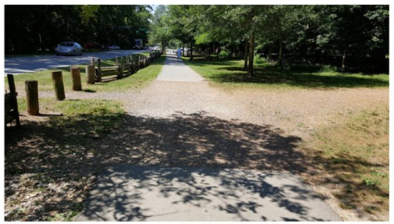
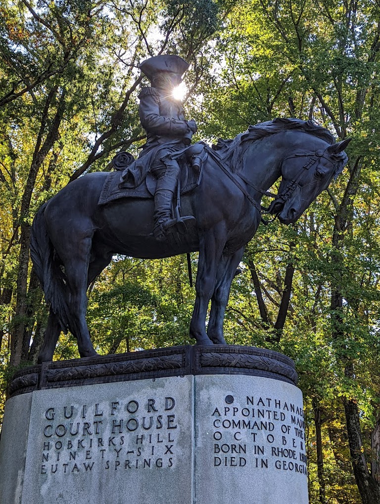
Statue of General Nathanael Greene near the Old Salisbury Wagon Road in Guilford Battleground Military Park.
Battleground Parks District Plan
Lots of big cities like New York City, Chicago, San Diego, and St. Louis contain parks with large green space, museums, and other attractions for people to enjoy. Greensboro now has that same type of park – the Battleground Parks District. Near the urban loop in the northwest region of Greensboro is a collection of significant public amenities contained in a 400- acre green space. These facilities: Guilford Courthouse National Military Park, Country Park, the Greensboro Science Center, Forest Lawn Cemetery and the Atlantic and Yadkin (A&Y) Greenway represent a significant opportunity for the city and the region to create a cohesive park that offers rich historic, educational, natural and recreational opportunities for both residents and visitors. Together these facilities are known as the Battleground Parks District.
In 1887, the Guilford Battleground Company was formed. It was conceived by Judge Schenck as an organization dedicated to preserving and adorning the grounds of the Guilford Courthouse battlefield. Through the work of acquiring the battlefield land, the company laid the foundation for its eventual adoption as a national military park. In 1917, the battlefield of Guilford Courthouse, in the state of North Carolina, was declared to be a national military park. Guilford Courthouse, by this time had grown to one hundred and twenty-five acres marked with twenty-eight monuments and graves and was the first Revolutionary War battlefield preserved as a national park. Country Park, part of a large tract of land purchased in 1924 with cemetery bond funds, officially open to the public on Independence Day in 1934. Work was initiated by Mayor Paul Lindley with assistance from the Civil Works Administration and the Federal Relief Administration. The bathhouse and boardwalks sited along the lakes were the main attraction. In 1957, the Natural Science Center opened. It was called the Greensboro Junior Museum and provided a small nature center and environmental programs. In 1964 the Lewis Center Rec Center was built in Country. In 1971, Greensboro Jaycee Park, the largest athletic complex, developed by the City of Greensboro, was built. In 1973, the Country Park zoo was deeded to the Natural Science Center, Inc. In 1978, the J. Spencer Love Tennis Center at Jaycee Park was built. In 1988, the Tannenbaum Historic Park opened to the public and hosted the first anniversary commemoration of the Battle of Guilford Courthouse. Park visitors learned about everyday life in the backcountry of North Carolina before, during and after the Battle of Guilford Courthouse. That year, the Hoskins House Historic District, located at Tannenbaum Historic Park, was officially listed on the National Register of Historic Places. In 1992 the Colonial Heritage Center opened at Tannenbaum Park. In 2009, a twenty-million dollar bond for the Greensboro Science Center expansion and renovation was approved by voters. (Info gathered from the Battleground Parks District Master Plan. For more info on the the proposed Battleground Parks District, check out this N&R article and this Yes Weekly article.)
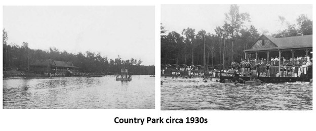
Extra Stuff:
So what do Horsepen Creek, the Battle of Guilford Courthouse, the Francis McNairy House and a library on Lake Jeanette Rd. have in common?
Well, around the time of the Battle of Guilford Courthouse, Francis and Mary McNairy and his family had a two story log house (later it was covered in clapboard) near Horsepen Creek. Today the basic vicinity of the house would be somewhere near where the Bicentennial Greenway connects with Old Battleground Rd, near Horsepen Creek (the actual creek not the road.) Remember from reading above, that this was near Martinsville, a town now extinct (basically now Military Park). The couple purchased a (from Herman Husband) a tract of land on Horsepen Creek, later famous as part of the scene of the Battle of Guilford Court House during the American Revolution. North Carolina State Records show payment to one John McNairy for services rendered, but no details of his war service remain. Because of the close proximity to the battle, Nathanael Greene declared the McNairy’s house be used as a hospital after the battle. The McNairy’s had ten children between 1763 and 1786. The eldest, John, studied law in Salisbury, NC and became acquainted with Andrew Jackson. When John returned to Guilford County, Jackson came with him and lived in the McNairy home during 1787-8. And so this is how this white clapboard house that now sits downtown got its fame (it was moved to the Greensboro History Museum in 1967). RunTheBoro will pass the Francis McNairy House on one of our later downtown runs. This week, when you turn onto the Bicentennial Greenway off of Old Battleground Road, you’ll be in the general vicinity of the house’s original location.

But what about the library on Lake Jeanette Road? Well this fairly new branch library was named for Glenn McNairy, a direct descendant of a family that has lived in Guilford County for about 250 years. (Yep, you guessed it, Francis McNairy’s family.) According to a News & Record article, “The McNairy’s settled in Guilford County in the 18th century. American troops under Gen. Nathanael Greene used their home as a hospital in 1781 during the Battle of Guilford Courthouse. The structure now sits outside the Greensboro Historical Museum.
In 1783, the son of family patriarch Francis McNairy became the first native-born resident to be granted a law license in Guilford County. Other McNairy family members became lawyers, doctors, teachers and school principals.
Glenn McNairy, the youngest of seven children, attended a one-room schoolhouse about a mile from the new branch library. He and older brother Walton owned and operated Tatum-Dalton Transfer and Storage, which grew from three trucks to 50. Glenn McNairy was active in the Greensboro Lions Club, Industries for the Blind, Meals-On-Wheels and the Greensboro YMCA. He died in 1998.”

Run #2
Bicentennial Greenway and Western Greensboro
Bicentennial Greenway
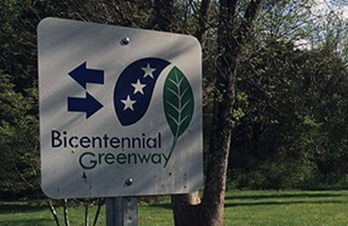
The Bicentennial Greenway is a 14.5 mile regional trail/greenway running through Guilford County, Greensboro, and High Point. Developed and managed by Guilford County, approximately eight miles of the northern section runs through the City and an additional seven miles run from the Piedmont Environmental Center to Highway 68 in High Point. Entities from the three jurisdictions are working on a plan to complete the missing segment between Greensboro and High Point. When complete, the Bicentennial will provide an almost 20 mile greenway that connects the City of High Point to the City of Greensboro.
How do I get there?
The Bicentennial Greenway can be accessed just north of the Guilford Courthouse National Military Park parking lot on Old Battleground Road. The Bicentennial Greenway travels northwest along Old Battleground Road and then changes direction southwest through wooded open space. Cross Battleground Avenue and take the sidewalk along Drawbridge Parkway to Kernodle Middle School. Follow the trail signs across the road into the woods to its current terminus near Horse Pen Creek Road. The new sections can be accessed from Guilford Elementary School and the Leonard Recreation Center.
Connections:
From the intersection of the Bicentennial Greenway and Lake Brandt Road in Greensboro, you can connect to the A&Y Greenway leading out to Bur Mil Park. The Nat Green Trail and Palmetto Trail are also accessible from the greenway (see map below for details). Guilford Courthouse National Military Park trails are accessible from the Bicentennial Greenway with parking available on Old Battleground Road.
The Bicentennial Greenway is a multiple-use trail. Bicycles are allowed and encouraged.
For more information about Greensboro’s awesome trails and greenways click here. For a map showing all of the Greensboro area trails and greenways click here.
Run #1
UNCG, Glenwood, Downtown Greenway, College Hill*, Greensboro College*, Westerwood* (*Long Route)
UNCG
Founded in 1941 by Gregory Ivy, first head of the Art Department at Woman’s College (now UNCG), the Weatherspoon Art Museum has grown from a university teaching gallery to a fully professional museum that is nationally recognized for its excellent collections and dynamic exhibition program. The Museum serves a broad audience of over 32,000 visitors annually, including UNCG students, faculty and staff; the Triad communities; and visitors from across the state, region, and nation; and an additional 24,000 students who take art history classes in the building.
As you pass the museum crossing over Spring Garden Street, be sure to look right over your shoulder and you’ll see the Pastoral or Third Sculptural Symphony II by Saul Baizerman.

RunTheBoro Run #1 runners/walkers will traverse the UNCG campus. The school was established as a women’s college by legislative enactment on February 18, 1891 as the State Normal and Industrial School and opened October 5, 1892. The school provided instruction in business, domestic science, and teaching with a student body of 223 and a faculty of 15 in its first year. R. S. Pullen and R. T. Gray gave the original 10-acre site in Greensboro, N.C. where the first building was erected with state funds totaling $30,000. It is the first and only public university in North Carolina founded for the purpose of educating women. In 1949, it became the largest all-female institution in the United States.
Peabody Park in the heart of today’s UNCG campus is a beautiful park-like campus area, but over 100 years ago when the school was just forming, this area was an untamed area of trails and paths.
The school has seen many names over the years, changing from the “State Normal and Industrial School” to the State Normal and Industrial College in 1896, and again in 1919 to North Carolina College for Women. In 1932, it changed to the Woman’s College of the University of North Carolina, when it became one of the three charter institutions of the Consolidated University of North Carolina, and changed again to the University of North Carolina at Greensboro when men were first admitted to the school in 1963. It is remembered fondly by many graduates of the Woman’s College simply as “the W.C.”
It’s a good thing RunTheBoro Run #1 is early in the morning, because I’m sure some of the runners (myself included) would be tempted to pull over at Yum Yum (near the UNCG campus) for some ice cream or a hot dog. Did you know? Yum Yum Ice Cream in its first incarnation was sold from a cart beginning in 1909 in downtown Greensboro. An early Greensboro postcard features the ice cream cart in front of the Courthouse. In the 1920’s, the business was moved to a free-standing building at the corner of Forest and Spring Garden Streets. Since the location was at the western limit of the city, the owner called the business West End Ice Cream. Around that time, he introduced the ice cream flavor Yum-Yum, a flavor that is believed to have included grapes, raisins, a grain. At any rate, people began saying, “Let’s go get some of that Yum-Yum ice cream.” The name stuck and became the official name for the store.
The shop is actually an ice cream factory with the product made in a back room, the old-fashioned way with vintage 1920’s equipment. They have had the same ice-cream maker for 25+ years now. He is very picky about the source of his ingredients as well as quality and consistency. The proof is in the taste of the ice cream. Currently, they feature 18 flavors. The store is, perhaps, equally famous for its tasty, bright red hot dogs” Yum Yum is surrounded on all four sides by the University of North Carolina at Greensboro.

Glenwood
During RunTheBoro Run #1, runners/walkers will travel down Grove St. in the Glenwood neighborhood. Did you know….during the early 1900s, Grove St. was an important hub of commercial and social activity. Several small grocery stores operated in Glenwood from the early 1910s up to the 1960s, most owned and operated by Glenwood residents. During the 1920s, new brick commercial buildings were built in the 1300 and 1400 blocks of Glenwood Avenue to house such businesses as a grocery store, drug store, barber shop, dry cleaners, butcher shop and cafe. New brick commercial buildings were also being built along the 1300 block of Grove Street. The largest commercial building to be built on Grove Street was the two-story brick building located at 1311 Grove Street. This building housed a grocery store downstairs with apartments above the store. With these and other amenities, Grove Street quickly became an important hub of commercial and social activity.

Did you know…..that in the late 1890s the area that now makes up Glenwood was away from the city and mostly farmland. Development of Glenwood began around 1906. The Carolina Real Estate & Investment Company began construction of the first 50 homes in the area using innovative methods for the time. Home buyers actually selected their home from a catalog of floor plans, then all the lumber arrived at the construction site pre-cut and ready to assemble. An interesting note about the Carolina Real Estate & Investment Company involved them offering the State of North Carolina 25 acres of free land in Glenwood, in order to entice relocation of the state capital from Raleigh to Greensboro – the state respectfully declined this offer.
Like any older middle class neighborhood, there are some houses that need some tender love and care, but as I ran through Glenwood, I discovered some of the most beautiful cottage style homes on Glenwood Ave, Marion St., Lexington Ave. and Haywood St. Here are a few of my favorites.
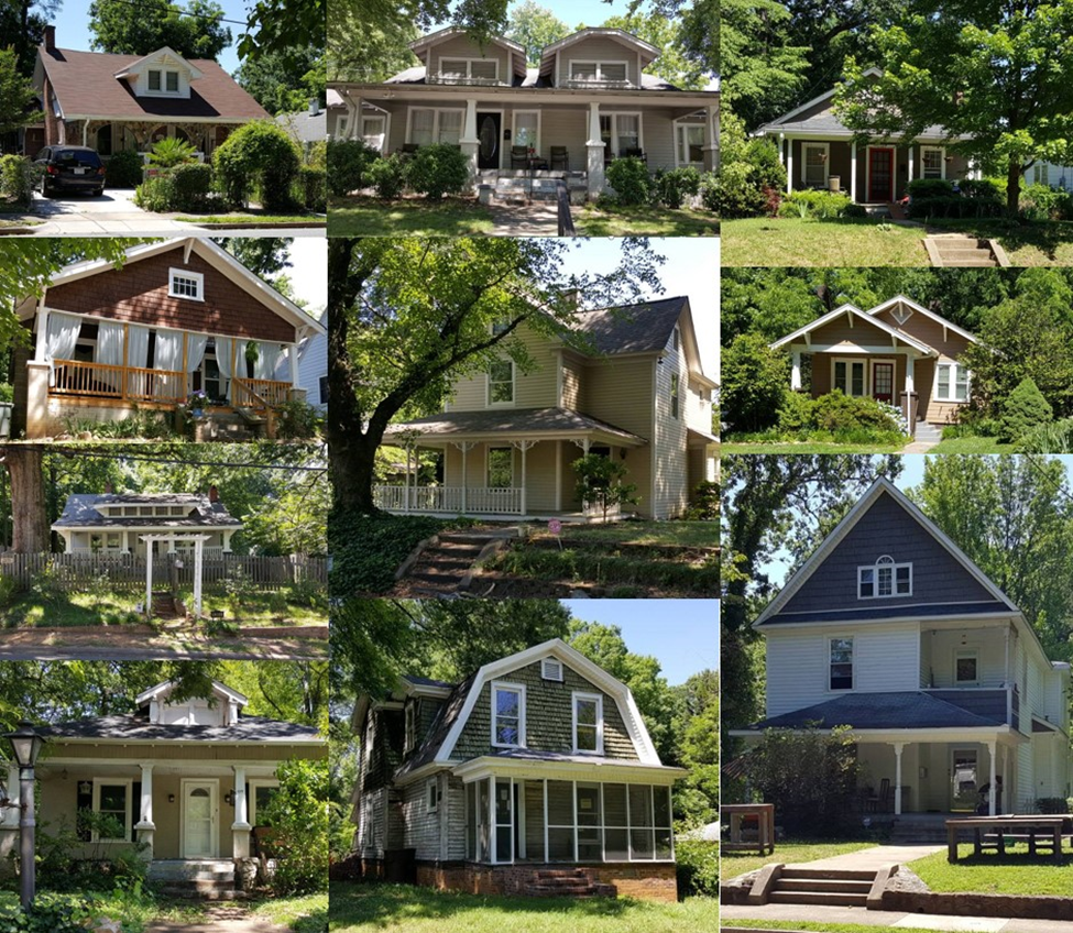
Downtown Greenway (Gate City Blvd to Spring Garden)
The Motion cornerstone is located where the Downtown Greenway crosses W. Gate City Blvd. The structure is made of stainless steel, with parts of it coated in three additional colors. Its appearance will change with the weather and with the time of day, and objects within the framework will rearrange themselves depending on where the viewer stands. The structure includes seating, allowing viewers to look up into it—and it is lit at night. Greensboro artist Frank Russell worked with students at Jones Elementary School to find or create the objects that are embedded in the stainless steel framework. Although the Cornerstone will not be designed to give viewers a specific message, the way the imbedded objects interact with each other will allow themes to emerge.

As you continue down the Downtown Greenway you’ll come to an underpass beneath the still active Norfolk Southern Railroad. With the consent of the North Carolina Railroad and Norfolk Southern Railroad, a collaborative art project was conceptualized for the passageway, and in 2010 partial funding was awarded to the Greenway for the creation of this project. In the pictures below, you can see what the underpass looked like prior to revitalization. Just past the railroad underpass you’ll come to the grand Downtown Greenway arch.
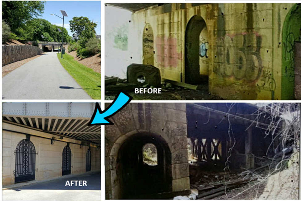
Just before reaching Spring Garden Street, you’ll encounter larger than life art replicas of furniture from the Blandwood Mansion created by artists Benjamin Kastner and Toby Keeton. The public art seating area reflects it’s proximity to Greensboro’s Blandwood mansion, and estate once owned by Governor John Motley Morehead, governor of NC in the late 1800’s, as well as to its location near “Foundation Place” a historic building that originally housed the executive offices of the Cone Export and Commission Company. Turn of the century furniture, including a traditional Victorian style settee and a more unusual “Tobacco

College Hill
Shortly after the long route runners, turn on to Mendenhall St., they’ll be entering the College Hill neighborhood. In that first block on Mendenhall, runners will pass by one of the oldest surviving fire stations in Greensboro. Old Station 5 located at 549 South Mendenhall Street was built circa 1897. The 2,670 square-foot two-story station originally housed a horse-drawn hose wagon. Located in College Hill, the historic engine house presently serves as a grocery store. Located between downtown Greensboro and the University of North Carolina at Greensboro, College Hill is one of Greensboro’s earliest neighborhoods. Some of the best examples of late Victorian architecture in Greensboro can be found here. Although its history can be traced back to the mid-nineteenth century, College Hill reflects life in Greensboro during the early twentieth century. There are examples of early homes and apartment buildings, churches, grocery stores, a drugstore, a mill, and two firehouses, one that dates back to 1890. Historic Greensboro College and UNCG are situated within the neighborhood’s boundaries.
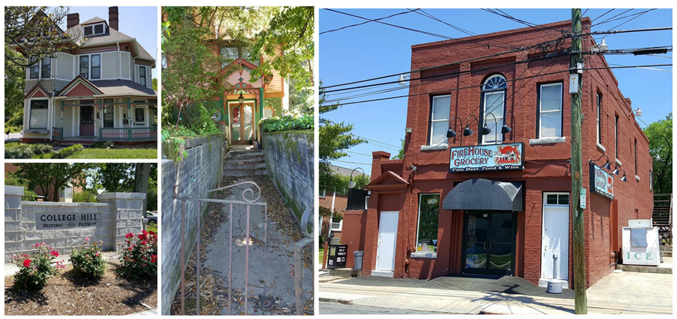
Greensboro College
Long route runners will run by Greensboro College. It was the first college to open its doors within the town of Greensboro and was originally named Greensboro Female College. The College first opened its doors for classes on April 15, 1846. Eighty-seven young ladies were in attendance at that time. Prior to the actual opening of the College, Greensboro Female Academy, which had begun as the Greensboro Female School in 1833, continued to operate and educate young Methodist ladies. In June of 1848, six young women became the first graduates of Greensboro Female College.
Upon arriving at the College, each young lady was tested in a number of areas (reading, math, writing, knowledge of specific topics, etc.) according to her interests, and based on her performance she was placed into one of four classes – first, second, junior, or senior. Consequently, it was possible for the young ladies to graduate from the College in as little as one year if their prior schooling had been sufficient to prepare them for the entrance tests at the College. Classes taught here at the College included arts, sciences, foreign languages, religion, and philosophy, in addition to music, art, and sewing.
Upon their graduation, each young woman received either a certificate of proficiency or a diploma depending upon her course of study. It was not until 1886 that the College began offering a true collegiate course of study that required four years of study regardless of how well the ladies tested upon their admittance. And it was not until 1913 that the College granted its first A.B. degree. In 1926, the College (then Greensboro College) underwent another major educational development when the College was admitted to membership in the Association of Colleges and Secondary Schools of the Southern States.
During the College’s early years, the movement and behavior of the young ladies was rather restricted and closely monitored. As the time between, 1846 and 1941 passed, the young women gradually gain more rights and privileges. In 1912, the faculty, administration, and alumnae successfully petitioned the Trustees of the College to change the College’s name from Greensboro Female College to Greensboro College for Women because they felt that the term “female” used in conjunction with “college” demonstrated a lack of progress in terms of educational development. And in 1920, the young women of the College and the alumnae successfully petitioned the Trustees to change the College’s name from Greensboro College for Women to simply Greensboro College because they felt that the term “for women” was unnecessary. Men were not admitted to the College as degree-seeking students until 1954

Westerwood
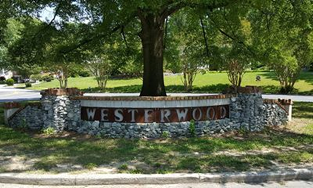
The houses shown below are just a few examples of the types of houses you’ll run by in the Westerwood neighborhood during RunTheBoro Run #1 this Saturday. Westerwood is centrally located between downtown Greensboro, UNCG and Friendly Shopping Center.
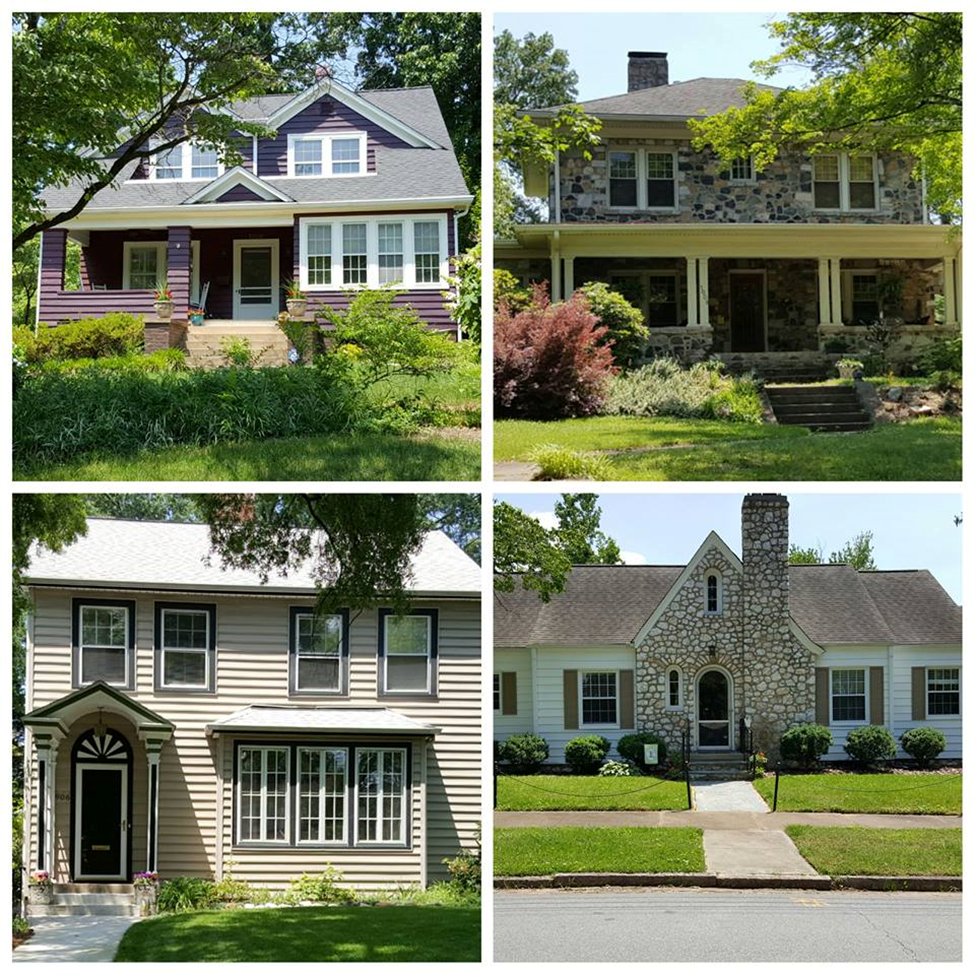
When it was built in the early 20th century, the neighborhood was one of Greensboro’s first planned communities. A 2001 study by the City of Greensboro’s Department of Housing and Community
Development concluded that “Westerwood may be one of the better examples of an early, planned community for middle-income groups in North Carolina.”
And that “as one of Greensboro’s earliest neighborhoods, Westerwood is a treasure. … Because of its traditional design, shady streets, proximity to thoroughfares, public transportation, parks, the downtown, colleges, schools, churches, and neighborhood shopping centers, Westerwood may well be the most ‘livable’ neighborhood in the city.”